
The Mt. Baker Highway is unusual. As one of Washington’s few high mountain roads that remains (mostly) open in winter, it provides access to the alpine that otherwise just isn’t feasible in other parts of the North Cascades due to a combination of snowed-in roads and the abbreviated daylight hours of winter.
The Highway, officially known as SR-542, is plowed to Mt. Baker Ski Area’s upper lodge at Heather Meadows (elevation 4300 feet), where one can find a plethora of amazing day trip options. One of the finest on offer is a mid-winter visit to Coleman Pinnacle, a volcanic crag that rises like a fang above Ptarmigan Ridge, about two and a half miles southwest of Artist Point.
The weariness fades as we eat a late lunch, marveling at how the warm light of winter accentuates the curves of heavy snow over the glacially sculpted landscape.
In recent years, Artist Point has become an extremely popular snowshoe/ski winter destination because it is a short and relatively safe trip from the ski area. But this is just the start of the trek to Coleman Pinnacle (6,403’). Since it is around ten miles and several thousand-foot of elevation gain out and back, depending on the route, a visit to the Pinnacle calls for backcountry skis or a splitboard. Snowshoes would be an exercise in self-loathing (although many have done it).

But a winter trip to Ptarmigan Ridge isn’t suitable most days. The route lies mainly above treeline and is therefore exposed to storms and lacks landmarks in poor visibility. Traveling in blowing snow without visual cues is a recipe for a miserable and possibly unsafe day in the mountains. So, a good weather forecast is the mandatory first step (https://forecast.weather.gov/MapClick.php?zoneid=WAZ567). Also, there are concerns about avalanche conditions. What does the Northwest Avalanche center say about hazards for the day in the Baker backcountry (https://nwac.us/avalanche-forecast/#/west-slopes-north)? Finally, sun can be a benefit but also a curse if the snow is unstable.

I’ve been out to Coleman Pinnacle most winters for the past 15 years, and the trips share a certain pattern, even as partners and details shift. First, there is the coffee-fueled ascent on 542, catching up with friends, route planning, craning your neck at certain points to look at how the snow hangs in the trees, where the winds are blowing, and how perfect (or not) the snow looks. Then, the shivering preparations at the parking lot, bantering with kindred spirits, jumping at the booms from the ski patrol prepping the ski area with hand charges (not a good sign for backcountry snow stability). Then you’re off, gliding on the southern edge of the ski area, always going too fast, hell-bent on getting to Artist Point as the sun illuminates Mt. Herman and Table Mountain.

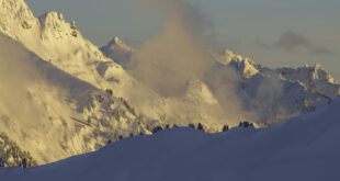
On this trip, we crest the buried parking lot at Artist Point. Kulshan dominates the scene to the west; we’re bathed in the warm light of a winter’s morning. Shuksan’s west face and its hanging glaciers lie in shadow, wisps of snow swirling across the rocky ridgetops. A quick stop to strip skins, root around in the snow to assess stability (some avalanche training is always a good idea: https://avtraining.org/aiare-level-1/). Then some quick turns down to the south side of Table Mountain, often dodging debris from the last avalanche cycle. We put our skins back on for the mile-long traversing climb under the imposing cliffs of Table Mountain to the eastern head of Wells Creek.

Here we start to experience the freedom of a landscape transformed by the deep snows of winter. The summer trail hugs the top of Ptarmigan Ridge, mainly on the south side, all the way to Coleman Pinnacle. But in winter, you aren’t limited to trails, which tend to traverse and avoid elevation gain and loss. Sure, Coleman Pinnacle may be the ultimate destination, but there is skiing to be done en route! And so, we strip off our skins again for a run down into Wells Creek, followed by another ascent, another run, and another ascent, going where the snow conditions take us, zig-zagging our way to the col to the southwest of the Pinnacle.
From the base of the Pinnacle, the final 200 feet rear up at an angle that most would find a bit challenging to ski. Add to this steepness the flutings that come from snow blasting around rocks and stunted mountain hemlock, and the easy decision is to leave the skis at the col to boot the final stretch, lightweight ice axe in hand. It is always more work than it seems, post-holing into voids around hidden trees and rocks, trying to avoid the cornice that often overhangs the north side, legs heavy from the bonus vertical that gliding on skis so often encourages.
But the view! The weariness fades as we eat a late lunch, marveling at how the warm light of winter accentuates the curves of heavy snow over the glacially sculpted landscape. Kulshan and its beautiful Park Glacier Headwall—only five miles away—dominates the western view, much more impressive than the view from the ski area. Steam can often be seen thinly rising out of the crater, a reminder that maybe the town of Glacier, located in the valley below, wasn’t built in the best location. Even with a down jacket, a chill creeps in, and a realization that winter isn’t the season to linger. Movement is life.

Rarely, but sometimes around the windswept summit of Coleman Pinnacle, I’ve caught movement out of the corner of my eye and stood amazed at ptarmigan quietly foraging in their brilliant winter plumage. Somehow, they are able to survive in the harshest winter months at the same elevation they inhabit in the summer. How?
Contemplating a question like this is an important way of turning the mind away from the toil ahead after that first exhilarating run down the north side of the Pinnacle. Now the real work begins: to climb out of the hole of Wells creek, picking your poison based on the energy left in the legs, the snow conditions, time remaining before sunset, and how psyched (or not) the party remains.

There are options for various routes back to Bagley Basin, which is one of the most attractive aspects of winter trips. In the summer, the most efficient route is typically preferred, usually, a trail or the path of least resistance when in trackless terrain. But on skis, options are plentiful in winter, and the exact route is subject to a hundred variations, offering the added pleasures of minor discoveries, often enjoyable enough to negate (some of) the pain of the inevitable climbing that follows a long descent. And so, over the years, sometimes I’ve found myself taking a long way back to the parking lot, descending from the top of Table Mountain in the last rays of the sun.
There is something extraordinary about seeing both the sunrise and sunset across a gloriously sunny winter’s day. In constant movement, covering many miles of untracked snow with good friends, sometimes it all comes together in a way that is difficult to put into words. Nevertheless, there you stand in the gloaming at the bottom of Bagley Basin, the last party out, watching the sunset fade from Goat Mountain as you slowly make your way to a mostly empty parking lot. At times like this, you can’t wait for the next time it all lines up again. It’s like a drug.
 Jason Griffith is a fisheries biologist who now spends more time catching up on emails than catching fish. Regardless, he’d actually prefer to be in the mountains with friends and family. Jason lives in Mt. Vernon with his wife and two boys.