
The North Cascades are a hiker’s paradise. The trail system that we enjoy in these northern mountains provides access to spectacular places and ranks among the world’s supreme networks of footpaths. Two of the finest routes in the Mt. Baker area are the Ptarmigan Ridge and Yellow Aster Butte trails. Both transport boot-clad acolytes across landscapes of unforgettable grandeur. Both are well maintained and within the comfort zone of most hikers. Both are at their best in the golden light of autumn. And both offer further explorations beyond the ‘destinations’.
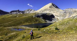
Above Ptarmigan Ridge

A dream-walk along a sinuous high-country ridge that meanders upward toward the glaciers of Mt. Baker, the Ptarmigan Ridge Trail offers non-stop superlatives with almost zero huffing and grunting. For that matter, the trailhead parking lot at Artist Point offers up superlatives. Artist Point is itself a scenic splendor, and in recent years it’s become a popular one. On sunny weekends, it’s packed. Snow lingers late here and the novelty of easily-accessed summer snow is a delight for low-land visitors, who bring kids, saucers and gleeful laughter. But fear not: the crowds thin somewhat as you head across the open slope below the chiseled cliffs of Table Mountain, although this first stretch is one of Mt. Baker’s most popular trails.
But the instantaneous grandeur is irresistible. In the distance, the beguiling black fang of the Coleman Pinnacle rises above the serpentine ridgeline. Knowing that soon you’ll be beside it, out there in that wild country, quickens the blood and energizes the spirit.

At the junction where the trail to Chain Lakes veers off, most folks turn right towards those enchanting lakes. Continue left, on to alpine wonderlands through sweeping meadows painted magenta and gold in autumn, hopping across wild little creeks beneath somber columns of basalt. You’ll traverse downwards beneath a dark wall along the top of a verdant basin. The contrast between the spare vegetation of the higher slopes and the lush meadows far below is stunning.
A short climb up the rocky trail (often snow-covered) has you on the ridge crest. Follow the trail to the right and continue upward, grunting slightly, and you’ll find a rocky outcropping just to the right of the trail, a fine spot to take a break, scarf some nuts and spend a moment letting the fortuitousness of the situation sink in.
When ready, press on. It gets better.
The trail traverses the steep ridge, heading southeast now. Berries and clumps of krumholtz give way to jumbled rock but the trail is artfully constructed and passage is easy to the next shoulder of the ridge (unless snow is present, in which case an ice axe would be de rigueur). A sharp turn here to the west and another splendid traverse. It’s uphill, but the grade is forgiving—and the ever-widening views will stimulate your adrenal glands.

I’ve been walking this trail for more than 25 years and on recent excursions I’ve noticed something that gives me pause. Snowfields that have always lingered here throughout the season have been vanishing. The last few years in autumn I encountered places where the trail disappeared in the scree for a while. This is where the snow used to be – no boots on the ground. Although new tread has since been established (and last winter’s prodigious snows will undoubtedly cover these places this year), the trend is, of course, unmistakable. Ptarmigan Ridge is Ground Zero for climate change.

You’ll see a heartbreakingly beautiful little tarn/lake below the trail to the south. It’s relatively new on the scene, born in the last few decades as the glaciers have receded. A side trail leads down in that direction. There are amazing spots to pitch a tent around the lake but don’t set up near the water and be sure to practice meticulous no-trace camping. The Forest Service suggests bringing bear cans for food storage and ‘blue bags’ for disposal of human waste. It’s obviously a very fragile area, deserving of extra respect—a special place where the land is raw and new, an opportunity to observe titanic forces up close, the tumultuous topography exposed without a covering of vegetation. And it’s popular with mountain goats. They travel in gangs here, doing the old soft-shoe on the broken rock for your morning entertainment. For heaven’s sake, don’t feed them.
The trail continues below the looming tower of Coleman Pinnacle, named for Edmund Coleman, the artistic soul who made the first ascent of Mt. Baker in 1868. The surroundings become more austere and Tibetan, and the route climbs—relatively gently—to another shoulder of the ridge. The northern horizon comes into view and the Border Peaks nearly steal the show. But there, in your face, is Koma Kulshan. The height of Mt. Baker is readily discernible for a hundred miles, but the sheer gargantuan mass of the volcano really hits home from here.
What’s that? A rough path continues upward, climbing seriously now, passing the stone circles of climber’s camps, and you find that you are climbing up one of the Portals, a massive rock monolith rising above the fractured ice of the Shoales glacier. Don’t stop now.

The primitive route concludes in dramatic fashion atop the East Portal at 6500 feet. A magnificent dead end: the next step would be oblivion. For non-climbers, this is a rare opportunity to stand atop a sublime and airy platform, rising from the glacial tumult. Plan to spend some time in a state of enraptured bliss here. Breathe the sweet, refreshing glacial winds, blowing cold and clean across the luminous blue ice from both above and below.
If you can turn away from the great glacier-encrusted face you’ll be transfixed by the sweep of mountains to the north, east and south. Shuksan swims in a sea of peaks. At sunset (or sunrise), when golden light illuminates the panorama, it’s phantasmagoric.
You’ll return the way you came, but you’ll be different.
Beyond Yellow Aster Butte

The trail to Yellow Aster Butte is a well-loved Cascadia classic and why not? In the upper reaches, the trail traverses sweeping meadows (crimson and gold in autumn), culminating in a climb to the top of the Butte where a 360-degree view takes in a panorama of Baker, Shuksan, the Border Peaks and mountains ad infinitum.
The journey starts at the well-marked trailhead occupying a hairpin turn on the Twin Lakes Road, off the Mount Baker Highway. The trail climbs through avalanche chutes and enters forest, working its way upward at a reasonable pace. Press on through wet little meadows, breaking tree line above a verdant valley. The way steepens as you break out of the trees, but the views make the huffing and puffing a small price to pay.

At the junction with the Tomyhoi Lake Trail, turn left and traverse a broad open slope on a gentle grade. The trail is a marvel of the trail builder’s art, crossing boulder fields and steeply-pitched meadows before crossing a pair of streams, the second of which is in a deep, often snow-filled gully. Resume climbing to a shoulder of Yellow Aster Butte and then contour to the west.
At a trail junction, the right fork transports you precipitously up the side of the Butte, passing the Maw (resist the pull) and eventually achieving the summit. The ascent is breath-taking (in every sense of the word). The top of Yellow Aster Butte is a sacred place. When conditions are right, the rich light can be a perfect complement to the sublime scene, lending a golden luster to the extraordinary hues of autumn in the alpine. Watching the sun go down and hiking out by headlamp is a time-honored tradition.
Yet, an alternative exists: Turn left at the last junction and descend the ingenious trail carved into a cliff, switchbacking down to a basin filled with sparkling tarns, where delightful campsites are plentiful. This is a popular place to pitch a tent, so solitude is in short supply. Splendor is not.

Beyond the tarn basin, a way trail climbs steep switchbacks up a shoulder of Tomyhoi Peak, where the upward mobility relents a bit. Pass a small but reliable snowmelt pool and continue toward the sky on well-defined trail. On a clear day, you’ll find yourself in the middle of a semi-circle of soaring mountains that includes much of the northern reaches of the North Cascades.
The climbing continues until you reach the Notch, an imposing defile that must be surpassed to reach the uppermost slopes of the mountain. You’ll down-climb on crumbling rock and then need your hands as well as your feet to ascend the other side. Goats are often seen cavorting in and around the Notch.

From here, it’s smooth sailing. Climb scree slopes, views expanding with every step, including the Pickets, Whatcom Peak and the distant complicated massif of Mt. Redoubt. As you continue up the undulating ridge, the Border Peaks—Canadian Border Peak (on the left) and American Border Peak (on the right)—form a great wall to the north, their towering rock faces a ruddy red
You need not summit—the last few hundred feet are treacherous. Climbing to trail’s end at 7200 feet, some 250 feet below the top, is a transcendent undertaking. The views are astonishing. You’ll be looking down on Yellow Aster Butte.
Where the trail disappears among the rocks, find a place to sit and contemplate the magnificent sea of peaks spread around you. This is one of the highest trail-accessible points in the North Cascades, a place to find perspective.
Spend as much time as you can here. Inhale the north wind. Watch the shadows dance. Many people live their whole lives without an inkling that such beauty exists.