
It was August 2020, mid-pandemic in peak backcountry camping season. As many outdoor enthusiasts remember, all mountain trailheads were jammed with eager hikers. Ironically, as we were all trying to avoid crowds and get some fresh air, we created crowding on popular trails (at least in the first few miles). My response was to get more creative with my route planning. I was inspired to plan a major culmination route for my summer of solo scrambling that included a dash of originality: steep bushwhacking off Stetattle Ridge through unknown territory to link up with an already remote climbing route, then finish with a bike self-shuttle.
I was totally gripped, which in climbing terms means being unable to move and too frightened to make a decision.
The seed of the idea was planted by local climbing legend Jason Griffith when he shared his discovery of a reasonable scrambling route up Mt. Prophet via a narrow rib of rock that he dubbed ‘Jacob’s Ladder.’ In all the available literature on climbing in the North Cascades, including ubiquitous internet trip reports and the venerable Beckey guides, no evidence existed that this route had been previously climbed. Griffith reported that the route required no technical rock climbing, and, hearing this, I speculated that I could likely handle it without a rope or partner. It seemed like a “bold enough” adventure that would stretch my limits—hopefully without breaking them.

However, since the route had already been described and was no longer the first ascent, I designed to spice it up a bit by adding some unknown variables. Stetattle Ridge sits proud and prominent immediately opposite the Big Beaver Valley from Mt. Prophet, running approximately the same length as the lowland trail approach from Ross Lake. What if I traversed the ridge, descended to the base of Mt. Prophet, and made a 40-mile loop of it?
No literature existed suggesting this was possible. I found it irresistible.
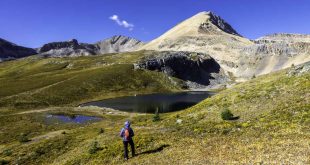
Stetattle Ridge

The hike to Stetattle Ridge begins by rising steeply from the town of Diablo towards the Sourdough Mountain lookout, then veers to the northwest on a faint, steep climber’s trail through forest brush to reach the ridge — about 5000’ gain in five miles. Most climbers who traverse this long, jumbled ridge with views in all directions of North Cascade gems—Jack Mountain, Colonial, and Snowfield Peaks, for starters—are accessing the Southern Pickets for remote and challenging peak objectives. Within a few miles, they head west towards Torrent Creek, Elephant Butte, and Azure Lake. I found no evidence that anyone had proceeded strictly along the spine-like ridge after its northern high point at 6,728’. I was intrigued.
To descend north from there through terra incognita towards McMillan Creek and reach an established trail near Big Beaver Creek at the base of Mt. Prophet was the genuinely exciting part. I pored over the satellite layer on Google Earth and obsessed over the spacing of topographic lines overlaid with images of rock and brush. I imagined a “reasonable” bushwhack without trip-ending cliffs.
The only helpful info came from Steph Abegg, one of the most prolific North Cascades adventurers who meticulously documents her findings for the climbing public. She writes on the SummitPost.org page dedicated to the Picket range:
“The Southern Range is noted for slender spires of rock rising above small glaciers on the southern slopes, and is visible from the North Cascades visitor center in Newhalem. The northern walls of the Southern Range are truly awe-inspiring. The basin defined by these walls is one of the most remote places in the continental U.S… From the saddle, it is possible to traverse into Terror Basin or traverse under the northern faces of the Southern Pickets via McMillan Cirque, one of the great hellholes of the North Cascades.”
I selected the basin below McMillan Cirque as my exit strategy, and somehow I read “most remote places” but missed the section on “hellhole.” Once I arrived, I understood what she meant, and yes, I can corroborate this description.
After locking my bike to a tree in the forest near a trailhead overflowing with cars above the Ross Lake Dam, I parked my car in the town of Diablo and began hiking up the radically steep Sourdough Mountain Trail. Few people were on the trail despite it being near the crescendo of an explosive hiking season. I traveled light with no tent and minimal food, hoping to complete the loop in three days of a solid weather window and hopefully find plentiful water along the way. I did bring an ice axe and strap-on crampons for Mt. Prophet, although neither was ever used.. I wasn’t sure how far I could get each day or where I would camp, but I aspired to reach Luna Camp in one day, climb and descend Mt. Prophet the second day, and have an easy third day walking out to the shores of Ross Lake on a relatively flat trail.
After five miles of boulder hopping along the gorgeous ridgeline, my attention focused on the prominent spine of Jacob’s Ladder looming ever closer; I realized my schedule was…ambitious. Gratefully, water sources were plentiful in the form of small tarns, or ponds of melting snow, keeping me hydrated and allowing for camping almost anywhere. I wanted to get close enough to my planned descent terrain just east of Elephant Butte to get a glimpse of it and wrap my head around this proposed linkup. Would I be getting through or returning to the car the next day dejected? I found a beautiful flat camping area near good water as crimson colored the evening sky, suggesting my 10-hour day was done. I decided to sleep on it.

I rose early, expecting a challenging day of making up time in order to get back on schedule. Unfortunately, I was also highly intimidated by my choices. I could descend now and reach a high saddle, then pick my way down a steep creek bed (which could be wet, mossy, and cliff-ridden) or stay on the knife-edge ridgeline until the last possible moment and turn left to pick my way through obvious cliff bands on drier terrain.
As I debated this crux decision, I caught a glimpse of a furry creature scampering quickly out of sight amongst the thick heather and boulder fields. My mind immediately projected a wolverine onto the scene. A great deal of my motivation as a backcountry, off-trail explorer springs from this tenacious and elusive creature as they eat this kind of terrain for breakfast. I realized later it was much more likely a big, fat marmot, but the specter of my spirit animal at precisely the moment my fear and indecision peaked was the precise nudge I needed. I followed the mysterious animal’s direction down the steep brushy spine. I never saw it again.
Death Needles, Rubble and Whitewater
The 4,000-foot drop from Stetattle Ridge to McMillan Creek over four miles would prove to be one of the most terrifying and challenging downhill hikes of my life. It began with steep, brushy terrain with only crumbly rock to hold onto, rotten snags to climb over and avoid impalement on, and worst of all, a phenomenon I call death needles. These are dried fir needles sprinkled on the hard-packed forest floor. Imagine tiny ball bearings lightly magnetized to a roller skate rink floor, then tilted at a 45-degree angle. The only way to walk on this petrifying surface is to grip the fir trees themselves. When the trees are spaced too far apart, movement feels as precarious as unprotected climbing moves on rock.
I survived a few hours of this, then moved into the slide-alder nightmare. As I left the ridgeline, picking an exit point I thought least likely to terminate in cliffs; I soon encountered impassable brush growing horizontally. I could most efficiently glide along the top in the downhill direction. Imagine floating on 2-inch stalks like a scene from a martial arts movie with warriors levitating on mature bamboo. Still, I needed to side-hill to evade unexpected drop-offs. I had no choice but to slide down in the plants’ natural direction of growth and accept the consequences. Turning back at this point by climbing up to the ridge seemed like a worse option.
Once I finally punched through the brush without major incident and saw a steep, dirt embankment above the raging glacial creek and snowfields below, I was elated. Surely I could now step onto the loose dirt and quickly reach easier going within moments. I regretted my rash decision immediately, as the soil had the characteristics of a lateral moraine, scraped hard and very compact with only tiny rubble embedded in it for texture. I pictured sliding downhill 70 feet at speed, shredding my hands as I feverishly grasped for futile purchase, only to be dashed into a field of boulders. I was totally gripped, which in climbing terms means being unable to move and too frightened to make a decision. I wanted my ice axe, but it was too late to fetch it from my pack. Forced to make precarious and delicate moves from loose pebble to loose pebble, I held my breath and prayed they didn’t break free.
I reached the creek bed and relaxed for a moment, but the situation remained dire. Four exhausting hours had passed, during which I had covered only two miles. I was miles from any real trail and now faced a new challenge. First: loose, ankle-twisting boulders; next, more unforgiving brush hugging the roaring McMillan Creek and a stretch of reasonably flat old-growth forest on the opposite side. I felt my prospects of climbing Mt. Prophet evaporating as the afternoon’s heat encroached.

The steep, rocky creek bed soon met the banks of McMillan Creek, and a new dilemma dawned on me—this was a raging river! It was boiling and gurgling with frigid snowmelt and ready to dash me and my backpack amongst huge boulders, likely pinning me in place. However, the only alternative was not much more attractive, especially after my experience on the mountainside above—bushwhacking through tall alder on the shoreline until I found a suitable log strewn across the banks (if I ever did). My quandary seemed hopeless until I walked just 20 yards downstream and found a miraculously placed log over the river, supported by a large boulder in the middle. It was precariously wet, and my toes dipped in the frigid water, but I could slowly shimmy down its length and reach the other side. Surely this was a good omen.
The following two miles of old-growth forest looked idyllic, and I hoped that with the massive trees shading the forest floor, it would be relatively brush-free and easy walking. Unfortunately, once again, I underestimated the ruggedness of the Cascades and soon faced a further humbling. I was now climbing over rotten logs four feet tall, jumping or falling off their crumbling sides into thick patches of Devil’s Club. Fallen trees would tempt me to use them as bridges to make better forward progress, only to reach a dead-end when they terminated in airy moves that could not be safely completed with a pack on, and I frequently had to backtrack. A visit to Mt. Prophet’s summit was slipping away once again.
I tried to appreciate the probability that no human had ever traversed this particular patch of land in recent history. That’s why, when I saw a bright piece of plastic littering the forest floor, I was quite surprised to see it was a mylar balloon, likely escaped from a birthday party far west of here. Unfortunately, despite my determined efforts to escape it, the human imprint is everywhere on this planet.
Jacob’s Ladder

When I finally emerged onto the well-worn Big Beaver Valley Trail maintained by the North Cascades National Parks system, I knew I would be physically okay, but I had a decision to make. Do I call it quits now? It was late in the day—almost 4 p.m.—and I hadn’t even reached the base of the Jacob’s Ladder route. Moreover, I was more than a half-day behind schedule, and rescue crews might be called if I didn’t exit to notify friends of my condition on the fourth day. I certainly wanted to avoid that but was loathe to give up the dream of summiting.
I told myself that I would make my way to Luna Camp, just to check out the scene. After that, perhaps I could camp with the modified plan of summiting Mt. Prophet and exiting partway to Ross Lake, then finish early enough the next day to make that critical phone call.
The campsites looked inviting and peaceful, tucked among the trees near Big Beaver Creek, with no one around except the buzzing and abundant mosquitoes. But sunset was hours away. So I decided to press onwards up the route, hopefully reaching a high platform with better views and a light breeze to keep the bugs off my face.

My dream of a flat bench with a view of the awe-inspiring Southern Pickets came true around 9 p.m. after 2500 feet of steep, technical hiking, so I called it a day. It had been 14 hours of near-constant movement covering only 12 miles. I was exhausted but hopeful that Day Three would be a more victorious one with fewer surprise obstacles.
I enjoyed the unparalleled view of a sunset over the Southern Pickets, and the bugs relented soon after dark, leaving me in peace in my sleeping bag.
I awoke at dawn, made coffee and breakfast, and attained the long-sought rock ‘ladder’ above treeline by 9 a.m. Casting my gaze occasionally upwards at Prophet’s summit, I was intimidated. The further I climbed on the sometimes loose and often steep rock, the more doubts crept in. What if those guys were much stronger climbers than me? They had protection if they needed it, but I did not. Did they not need any of it? The exposure in a few spots along this knife-edge ascent was daunting. I wore a helmet, but a long fall would certainly injure me, and I was clearly out of range of a quick rescue. I moved with the greatest of care, testing every hold for security.
The final scrambling involved some loose scree among ominous dark towers. The sense of isolation was powerful. The trip began to feel like a pilgrimage.
It was unclear which promontory was the highest, so I picked what looked like the easiest. Suddenly, I was perched on the proper summit, affirmed by the presence of a summit register. Opening the tiny, yellow book titled “Mt. Prophet, 7640+,” I knew my dream had been realized. Of course, this is an emotional moment on any challenging summit, but a bit subdued with no one to celebrate with other than the names of a few recent climbers entered in the register.

But with a still unfamiliar descent ahead of me and a very long day remaining, my euphoria was, by necessity, short-lived. I needed to move fast and make up for lost time, hoping to find a water source somewhere on the descent. After two full days and a long morning of scrambling, the total mileage so far was 24 miles and over 10,000’ of elevation gain. If I reached my bike at the Ross Dam Trailhead tonight, the remainder would require hiking 16 more with a 5,500’ descent.
The next mile to a nearby false summit required more delicate rock hopping and navigating a few menacing-looking scrambles, and then the route dropped off through heather and forest. The climber’s trail was faint, made of compact dirt with loose sand on top, and very steep. Nevertheless, thirsty and bone-weary, I pressed on with a renewed sense of urgency.
I staggered out onto the Big Beaver Valley Trail after more than two precipitously steep miles downwards (with much fretting, cursing, and struggling but only a little falling). Now I could shuffle along and try to find joy in the views. Enormous old-growth trees surrounded me, and the bright glacier-fed creek flowed by, but the heat was oppressive, and the biting flies became incessant. I swatted them with my ball cap and kept hustling.
It occurred to me I could reach the Ross Lake boat shuttle and shave tedious miles off the ending, but it was unlikely to work without a reservation, and I had no notion of their schedule. I kept going. Tiny tree frogs littered the trail. Six miles clicked by in two hours or so, and I found myself near the western shore of Ross Lake at last.
Darkness fell, and the headlamp came out. Abundant bear scat littered the trail and my pace quickened yet again. Encountering a bear alone in the dark seemed like a bad way to end this nearly successful epic journey.
I limped across the concrete rim of Ross Dam and climbed the last three quarters of a mile to Highway 20. I was filled with joy to find my bike and climbed, exhausted onto the seat for the ride to my car, coasting into the sleepy town of Diablo under the watchful eye of a security guard around midnight. I had been moving for 16 hours.
I tallied the number of people encountered in three days: a half dozen on the first two miles of the Sourdough Mountain Lookout trail on Day One, absolutely none on Day Two, and only a pair of hikers fetching water near the 39 Mile Campground on Day Three.
If attaining isolation just miles off the highway in a popular National Park was my main objective, I had been highly successful. Summiting Mt. Prophet via Jacob’s Ladder was a total bonus, as I was on the precipice of failure for an entire day. Determining that the linkup from Stetattle Ridge is—and maybe always will be—a completely unreasonable passage might be valuable in its own right. It is comforting to know there are still places on this planet where humans simply don’t belong.
 Ryan Rickerts is a photographer, aspiring novelist, and lifelong resident of the PNW, growing up in North Idaho and residing in Bellingham since 2000. The local mountains never cease to inspire him to keep finding adventure in the unknown places nearby. Visit him on Instagram at @dove_prism.