
People cross-country ski all over the country. Even in New Jersey. But few are fortunate enough to have – at their ready disposal – scenery on anything close to the magnitude that we enjoy here in the northwest corner of these United States. These blessings should be counted.
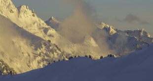
The destinations that radiate from the Mount Baker Highway are sufficient to keep us busy (and gaping) for a lifetime of euphoric exploration. Fetching excursions beckon, seemingly around every bend of this magic road. Options are numerous and diverse. Everything from sweet and easy glides along the Nooksack River to demanding sojourns that will transport you to wind-blasted summits.
For the moment, let’s survey a host of lower-elevation routes that follow Forest Service Roads emanating from the Mt. Baker Highway. Set your odometer to zero at the Glacier Public Service Center (Ranger Station) – all of the trailheads are described in terms of the distance from this point. Since these trails are all at relatively low elevations, conditions are dependent on suitable snow cover. You can check the current snow depth at the SNOTEL site. Definitely check avalanche conditions at the Northwest Avalanche Center.
You can get more info about these – and other skiing options – at the Nooksack Nordic Ski Club website. The NNSC has maintained and groomed the Salmon Ridge Cross Country Ski Area since 1992 and is a great source of information, education and camaraderie. Thanks to the club for contributions to the below trail descriptions.

White Salmon Road (#3075)
This area is a great choice when the snow cover is dodgy – at 3,300’ it usually has plenty of the white stuff and is the highest route on this list. Park in the switchback (off the road, obviously) below the turn-off for the lower lodge at Baker, about 18 miles from Glacier. Parking space is very limited here. Head off down the snow-covered road, enjoying spectacular views of Mt. Shuksan and the surrounding peaks. Unusual in these parts, this trip descends from the trailhead, which means a climb at the end of your tour. After a mile, you’ll get some great views of Shuksan. The further you go, the better the views and the thinner the crowds. I’ve over-nighted out here and saw nobody but my crusty companions.
Glacier Creek Road #39
Located 0.7 miles east of the Glacier Public Service Center just inside the National Forest Boundary and 8.5 miles long (measured from the Thompson Creek Bridge), the Glacier Creek Road climbs from 1,000′ to 4,000′. Park along the roadside at snowline. One avalanche path crosses the road and runs occasionally. If you haven’t confirmed current avalanche conditions, don’t go. Glacier Creek Road is groomed for snowmobile use and provides early- and late-season access to good backcountry tours in the exceedingly scenic Grouse Butte and Heliotrope Ridge areas. On a clear day, you’ll be treated to glorious views of Mount Baker. The snowmobile grooming provides great skiing and easy snowshoeing right after it’s been groomed, but attracts unpleasant crowds of machines on the weekends. Visit in midweek or at the beginning or end of the season. For the adventurous (and well-prepared), the Heliotrope Ridge Trail is closed to machines and open to possibilities.
 Deadhorse Road #37
Located at the beginning of the Glacier Creek Road (#39), Deadhorse Road turns left and meanders for 14 miles, climbing from 1,000′ to 4,000′. Parking is along the side of the road at snow line. The route is fairly level along the Nooksack River and then begins a long gradual uphill climb, reaching the trailhead for Skyline Divide at 13 miles. Skyline Divide is an excellent early- and late-season skiing destination (when you can drive much of the way up the road), offering wide open bowls and great views, although you’ll have to do some work on the steep trail to reach them. The lower sections of Dead Horse can offer great snowshoeing and skiing along the river but because of the low elevation, this area often lacks an adequate snow pack.
Canyon Creek Road #31
Located 1.9 miles east of Glacier Public Service Center, the Canyon Creek Road offers another low-elevation outing. The road is 14 miles long and the elevation climbs from 1100′ to 4500′. Parking is along the side of the road at snow line. Although it makes for a lengthy ski, Canyon Creek is snowmobile central and tends to be cacophonous on winter weekends.
Wells Creek Road #33
Beginning near Nooksack Falls at 1800′, the Wells Creek Road climbs an extremely moderate 1000′ in 12 languid, unhurried miles. Parking is on the Highway or at the falls (a de rigueur side trip). Located 7.1 miles east of Glacier at the Nooksack Falls turnoff, the road is closed to vehicles and snowmobiles at the Falls from November 1 – July 1, making this a great destination for solitude, quiet and wildlife watching. You’ll cross an avalanche area after three miles in an old burn, so go no farther unless avalanche danger is low. Snow can be questionable here due to the low elevation (and due to the gate, you can’t drive up the road to find the snowline) but a visit in mid-winter when the snowpack is sufficient offers great scenery and even opportunities for lonely camping beneath a star-dazzled sky.
 Twin Lakes Road #3065
Located 12.7 miles east of Glacier, the Twin Lakes Road angles left just past the Shuksan Maintenance Shed at 2,000. Parking is along the side of the road (don’t park in the maintenance yard). This scenic road – which is closed to snowmobiles – is seven miles long and climbs 3200′. A steep uphill climb (with a corresponding challenging descent on the way back down) leads to sweeping views of the surrounding peaks. After four miles, the avalanche danger is extremely high and travel beyond is unwise.
Hannegan Road #32
The Hannegan Road is located 13.1 miles east of Glacier and one-half mile before the Salmon Ridge Cross Country Ski Area. There are 3.5 miles of road, and an elevation gain from 2,000′ to 3,100′. After a gentle, gradual ascent in first mile, the road steepens. There is an avalanche hazard past 3.5 miles and travel is not recommended beyond this point.
Salmon Ridge Cross Country Ski Area
The good people at the Nooksack Nordic Ski Club maintain this delightful area, grooming trails that radiate from the huge sno-park just beyond the Hannegan Road and Nooksack River, 13.6 miles east of Glacier (on your left when heading east). At 2000’, the snow here can be touch-and-go sometimes but the trails are a joy. Enjoy easy riverside skiing with a few minor hills to add interest. This is a great place to take beginners and a fine setting for a winter picnic. The area is popular with snowshoers too. Find a trail map here. Note: You’ll need a Sno-Park permit to park.