


I’ve spent a lot of time exploring the magnificent nooks and crannies of northwest Washington, enjoying untold splendor along the way. But I had never driven the meandering scenic excursion known as the Cascade Loop. Described as Washington’s Ultimate Road Trip, the 440-mile loop traces an oblong circle from saltwater to the Columbia Highlands and back to saltwater, crossing the magnificent Cascade Range twice.
Wenatchee businessman Gordon Ohme masterminded the Loop in 1978 when he gathered some of his friends at a local pub. Armed with a map and pen, he and his cohorts drafted a Loop to connect the scenic and recreation hubs of the diverse country north of Seattle. Their devised route spanned a rich palette of vistas, iconic landscapes, and previously off-the-beaten-path destinations. It is this track my traveling companion and I were prepared to traverse on a crisp autumn weekend.
By now, the light had grown soft, casting long shadows in the canyons. The sweet perfume of sage drifted in through the car’s open window.
I’d seen a lot of beauty in my years of traveling this corner of the world, so I approached the journey from a local’s perspective, but one ready for a fresh look at my magnificent stomping grounds. I was not disappointed.
We turned off I-5 in Burlington and headed east up Highway 20 beside the mighty Skagit River, its muscular waters coursing down from the mountains, past the little moss-roofed clusters of homes in towns with names like Rockport and Marblemount, resembling villages in Middle Earth, blending into the green forest.
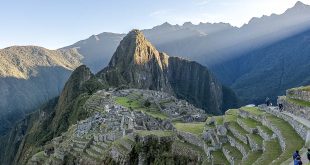
Up we went into North Cascades National Park, a familiar and beloved summertime haunt. We pulled in at the Washington Pass Overlook and walked the paved paths that led to the overlook. How was it that I had never ventured to this little perch above the highway in all my years living in Washington? The view, I found, surprises—and inspires, offering a perfect vantage point of the Liberty Bell Group, rising like Valhalla above the highway.

Crowning the scene were the larches, golden in the afternoon light. The Larix lyallii, or subalpine larch, glow an iridescent orange when autumn comes calling. The sight infected me with what has become known as ‘larch madness’ and I decided to find a place where I could get up close and personal with these magnificent trees.
After descending the curvaceous switchbacks on the eastern side of the pass, we pulled into Mazama, a recreation haven boasting an impressive Nordic ski system that churns out Winter Olympians at a remarkable rate. A few miles of gravel road delivered us to the Goat Peak Trailhead, where we parked and laced up our hiking boots.
A trail of moderate grade ushered us into the realm of larches, delivering us onto a ridge crowned by the Goat Peak Lookout. One of the few fire lookouts still in use during times of high fire danger, the views from the lookout extend for miles: A turn to the right revealed the Cascade Range; a turn to the left looked down into the rolling hills of the Methow Valley, tawny with hay and aspen, and our next destination.

Pulling into Winthrop, the view of the Methow River from the Spring Creek Bridge proved irresistible, and we got out for a closer look at the sparkling water. The road became more of a back road, passing through the picturesque hamlets of Twisp, Methow, and Pateros on its way down to the Columbia River. We passed between towering canyon walls, the tumultuous river taking center stage.
Few natural features dominate their setting the way the Columbia does. One need only remember that this river is dammed more than 60 times from its headwaters to the sea to understand what an absolute hellion it must have been unbridled.
By now, the light had grown soft, casting long shadows in the canyons. The sweet perfume of sage drifted in through the car’s open window. A sign announced the Columbia Breaks Fire Interpretive Center, and we pulled in, curious. We found three retired fire lookout towers, now keeping guard at the bottom of a canyon. A gravel path wound between each, with information on the impacts of wildland fires, the history of fire management, and how the next “big one” might be prevented.
After a brief stop in Chelan for dinner, darkness fell as we climbed back into the mountains and into Leavenworth’s Icicle Canyon, where we pitched our tent for the evening.

In the morning, we enjoyed a breakfast of apples from a roadside stand, Cosmic Crisp from the Wenatchee Valley, a proven way to begin your day enlightened. I was inspired to backtrack a little to the sandstone spires of Peshastin Pinnacles, located in the park of the same name near the town of Cashmere. These spires kindled my love affair with climbing when I climbed here as a 13-year-old boy many moons ago. I spent the morning on the rocks, enjoying the nostalgia.
Back on the road, we continued westward beneath gathering clouds.
From here, the Loop ascends to 4,061 foot Stevens Pass, following the rail lines that preceded the road, the surroundings growing greener with each mile. The Skykomish River gathered itself beside the road in a deep gorge tossed by rapids. This is the playground of whitewater rafters during the summer months, but now the river was quiet, and we were alone when we pulled over and walked down to its banks.
It’s a marvel just how quickly the forest changes in the 30 or so miles on either side of the pass.
Ponderosa pines and fire-savvy grasses of the steppes dominate the eastern side, and on the west slope, rain-soaked Douglas firs tower overhead, dripping with moss.
It was a wonder to traverse through entire ecosystems in a day. But again, the road called, and we continued westward, headed for the coast.
A steady rain beat on the windows of Cozy’s Roadhouse, built in 1900 and operating as a tavern and community meeting place since 1932. Getting there involved a ferry ride across a rain-whipped Possession Sound to Whidbey Island and we were glad to be indoors.
Insulated from the bustle of the I-5 corridor, Whidbey—the largest of the San Juan Islands— is decidedly on island time. It is a patchwork of historic farms and rambling Salish Sea vistas, a step back in time. (Captain George Vancouver stopped here in 1792, naming the island for his Lieutenant Joseph Whidbey).
After a late lunch of fish and chips, we rambled up the island to Ebey’s Landing, where a broad prairie stretches from one side of the island to the other and then falls away into sea cliffs.

The rain that had been steadily falling since we crested the Cascades began to subside, and almost on cue, a curtain of clouds parted and allowed a sunset view. I stood with my feet in the surf, now nearly 150 miles west of our furthest point on the Loop in eastern Washington. Between the two points, I had discovered a diverse banquet for the senses: sun-drenched valleys, green shadow-filled forests, rushing blue-green rivers, snow-dappled peaks, and finally, the tranquil murmur of the sea lapping on golden shores.
The Cascade Loop makes it easy to experience this wondrous cross-section of the richness of the Pacific Northwest. Just get in the car and go.
Ohme Gardens
Ohme Gardens, located on the Cascade Loop in Sunnyside, WA, near Wenatchee, offer visitors a chance to stretch their legs and experience an oasis of botanical beauty on a one-mile path that visits four waterfalls, seven pools and offers spectacular views of the Columbia River Valley and the snow-capped Cascades. Herman Ohme created the gardens on what was a dry, barren bluff when Ohme and his wife Ruth purchased the land in 1929. The couple worked tirelessly, transplanting evergreens, creating stone pathways, and watering the nine-acre gardens using five-gallon milk cans. When Herman died in 1971, their son Gordon (the visionary behind the Cascade Loop) took over the care of the gardens. In 1991 the gardens were sold to Washington State Parks and are now managed by Chelan County. The gardens are open to the public from April 15 to October 15.
 Nick Belcaster is an adventure journalist who may be based in Bellingham but calls the ancient ice and spires of the North Cascades home. He contributes to local and national publications, and his work focuses on the intersection of recreation, energy, and the environment.

2 comments
Pingback: How to be a Responsible Road Tripper in Hawaii – AdventuresNW
Pingback: 17 American Road Trips That Are Heavy on Scenery But Light on Traffic