
Winter has descended upon us. Skyline Divide, Yellow Aster Butte, and all of your other favorite high country romps are now— thanks to a thick shroud of snow—pretty much off limits until next summer. But there’s no need to put away your hiking shoes. There are scores of low country hikes that for the most part remain snow-free all year long. And many of these trails offer stunning views, excellent wildlife viewing—and an added bonus of solitude in these crowd-free winter months.
Here are 10 of my favorite places to hit the trail in Whatcom County when the high country is blanketed white.
Lily Point Marine Park

- Whatcom County Parks
- Point Roberts
- Roundtrip: 1.6 miles
- Elevation Gain: 220 feet
The crown jewel of the exclave of Point Roberts, Lily Point encompasses nearly 250 acres of mature forest, extensive tidal flats and impressive high bluffs. While Lily Point is the largest natural tract on Point Roberts, it wasn’t always so. From 1884 to 1917 the Alaska Packers Association (APA) operated a large salmon cannery here. All that remains of it today are barnacled pilings and scattered rusting debris. Thank the Nature Conservancy, Whatcom Land Trust, and various state agencies and concerned locals for preserving it. Hike from lofty bluff tops to secluded beaches and savor stunning views across Boundary Bay to Mount Baker. And count the eagles along the way—there are more here than on a Philadelphia football franchise’s active roster.
Baker Preserve

- Lummi Island Heritage Trust
- Lummi Island
- Roundtrip: 3.6 miles
- Elevation Gain: 1030 feet
Note: dogs prohibited; all visitors must sign register; group size limited to six.
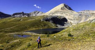
Visible from far and wide around the Salish Sea, 1,665 foot Lummi Peak is one of the highest summits in the San Juan Islands. Thanks to the Lummi Island Heritage Trust’s Baker Preserve, you can now hike up this prominent landmark. Wind up steep slopes beneath a cloak of greenery to a series of high ledges. Watch eagles, hawks, and vultures ride thermals and enjoy eagle eye viewing of the islands and the Salish Sea sparkling below. Pick out Sinclair, Cypress, Orcas, Clark, Matia, Sucia, Patos and Saturna islands. You can take in views of a few frosty Canadian north shore summits, too.
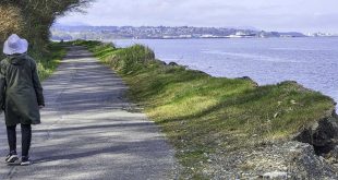
Semiahmoo Spit

- Whatcom County Parks
- Blaine
- Roundtrip: 2.0 miles
- Elevation Gain: none
Your choice—a paved trail along Drayton Harbor sporting breathtaking views of Mount Baker; or a sandy and rocky beach along Boundary Bay granting glimpses of snowy British Columbia peaks hovering over White Rock and South Surrey. The bird watching is exceptional on both sides of the narrow spit. And there are plenty of historical points of interest, too. The Semiahmoo Spit was once home to another massive APA cannery, the largest cannery in the country. At the far end of the spit, where a resort now sits—you can roam around checking out some of the remaining APA buildings and structures from the cannery days. Make a loop on this protruding piece of land just south of the international border and enjoy all of its charms.
Hertz Trail-Lake Whatcom Park

- Whatcom County Parks
- Roundtrip: 6.2 miles
- Elevation Gain: 60 feet
Follow an old logging railroad bed along the semi-wild northern shore of massive Lake Whatcom, one of the largest natural lakes in the state. The shores of this lake once bustled with townships, mills, and mines. Now homes dot much of its southern shore, while park lands protect the lake’s northeastern stretch. The Hertz Trail utilizes a near level rail bank hugging the forested shore of this glacial-trough lake. Enjoy waterfalls and quiet beaches along the way as well as old-growth forest groves, shoreline ledges and a couple of covered bridges. This hike is especially tranquil in winter when motor boats are absent.
Stimpson Family Nature Reserve

- Whatcom County Parks
- Roundtrip: 4.4 miles
- Elevation Gain: 350 feet
- Note: dogs prohibited.
The Stimpson Family Nature Reserve encompasses more than 350 acres of mature forest and two wildlife-rich wetlands on a ridge above Lake Whatcom. The trails within the reserve are a real treat to hike, thanks to master trail builder Russ Pfeiffer-Hoyt and the Whatcom Land Trust. Wander through groves of towering trees including some that are more than 400 years old. Dart through and around dark ravines; and meander alongside placid pools of water. At Geneva Pond, take a break on a granite bench and admire the surrounding tall timber reflecting in its peaceful waters.
Chuckanut Ridge

- Whatcom County Parks and Washington State Parks
- Chuckanut Mountains
- Roundtrip: 10.8 miles
- Elevation Gain: 2000 feet
A long rugged ridge of gnarled firs and sandstone ledges, Chuckanut Ridge offers challenging hiking and sweeping views. Follow the up and down ridge clambering over steep knobs, stopping along the way to catch your breath and savor the scenery. Enjoy excellent views of Bellingham nestled below against a northern backdrop of jagged BC peaks. And be wooed by giant snow cone Mount Baker hovering on the eastern horizon. Start from the North Chuckanut Trailhead following several trails to the Chuckanut Ridge Trail. Then let the fun begin. Wind beneath ledges and around boulders and steeply climb. Reach the first of several excellent viewpoints and gawk. Go farther if you like, on an up-and-down, at times rough-and-tumble trail all the way to Cleator Road.
Fragrance Lake

- Washington State Parks
- Chuckanut Mountains
- Roundtrip: 4.4 miles
- Elevation Gain: 1050 feet
- Note: Discover Pass required
Perhaps the most popular spot in the Chuckanut Mountains, Fragrance Lake sees legions of hikers and runners old and young and of all shapes and abilities. Follow a sometimes steep foot-traffic only trail through groves of big old growth trees to the small placid lake—the gem of 2600-acre Larrabee State Park. Then amble around it, passing babbling brooks, big cedars and steep sandstone ledges. On the way up, be sure to take the side trip to a scenic madrona-framed lookout for views across a glistening Samish Bay dotted with emerald islands.
Cedar and Pine Lakes

- Whatcom County Parks
- Chuckanut Mountains
- Roundtrip: 5.2 miles
- Elevation Gain: 1625 feet
Don’t let the short distance to these two little lakes tucked high on Chuckanut Mountain fool you. You’ll get a good workout getting to them thanks to the steep initial approach. But once you conquer that climb, enjoy exploring the small lakes and the knob above them where views are achieved. The entire way to the lakes is through deep unbroken forest. The trail, an old skid road, passes rushing creeks, pocket wetlands and a few patches of big old trees. And be sure to take the Cedar Lake Overlook Trail to a precipitous ledge for a good view of Mount Baker and Lookout Mountain.
Horseshoe Bend

- Mount Baker-Snoqualmie National Forest
- Mount Baker Highway
- Roundtrip: 3.0 miles
- Elevation Gain: 300 feet
A gentle trail along a raging river, Horseshoe Bend is perfect for evening and early morning strolls. Perfect too, for introducing children to the wonders of nature. Perfect for stretching your legs out on the way to Heather Meadows. Perfect for watching diving dippers. And perfect for staring into tumultuous rapids. But, a terrible place for carrying on a conversation. The river’s roar is deafening as it plunges over boulders and ledges and squeezes through chasms. But its allure is oh-so intoxicating.
Baker Lake

- Mount Baker-Snoqualmie National Forest
- Baker Lake
- Up to 13.2 miles one way
- Elevation Gain: up to 1200 feet
- Note: Northwest Forest Pass or Interagency pass required.
Created in 1959 by construction of the Upper Baker River Dam, Baker Lake is the byproduct of flood control and our propensity for flicking on the lights. The lake is drawn down during the winter months revealing a muddy bed of stumps. Not very pretty. But the lake is not the attraction of this hike. The wild Baker River flowing into it; cascading tributaries feeding it; groves of old-growth giants gracing it; views of Mounts Baker and Shuksan towering above it; and a cool little suspension bridge are the draws of this hike. The Baker Lake Trail is also part of the long distance Pacific Northwest Trail. Do an easy out and back hike from either the lake trail’s northern or southern trailhead—or arrange for a shuttle and do a grand 13.2 mile one way trek.
 Craig Romano has written and co-written 20 books, mostly on hiking. He has hiked more than 20,000 miles in Washington. His new Urban Trails Bellingham (Mountaineers Books) spotlights great places to hike and run in Bellingham, the Chuckanuts, Skagit Valley and Anacortes. Visit him at CraigRomano.com.