
One week last summer, my husband and I, both avid trail runners constantly looking to challenge ourselves, decided to summit a peak every day. Because we live in Bellingham, WA., our first few runs took us to local mountains like Stewart, Oyster Dome, and Lookout before we decided to venture to longer routes across the border. Howe Sound Crest, nestled against Vancouver’s North Shore, sounded ideal: not only did the distance sound manageable, but tough—roughly 18 miles, point-to-point—but the trail would also transport us to several peaks along the way, bringing up our total peaks for the week. It sounded like a plan, so early Sunday morning we made the hour and half drive to Porteau Cove, south of Squamish, B.C., where we parked our car and arranged for a ride to drop us off at Cypress Bowl, where we would begin our journey.

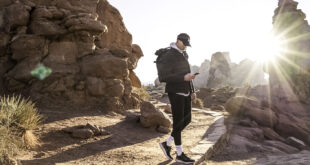
The sky was soft pink and the air still cool when we started; I was glad to have packed a few extra layers. Although the weather forecast promised ideal conditions—clear skies and a high in the eighties—being prepared was critical for this trail. Along with packing enough food to last 12 hours, we had enough water to last until Magnesia Meadows, where we’d be able to refill.
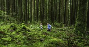
While we expected the trail to climb, we weren’t prepared for just how much climbing we’d be doing. Within the first few miles, the trail was already switchbacking up steep, dark forest. Our first peak, St. Mark’s Summit, had already been reached by early morning hikers who slapped at their thighs, attempting to chase off the swarms of mosquitoes that were engorging themselves without mercy. We stayed long enough to enjoy the view of Bowen Island below, a green enclave surrounded by a berth of blue, before continuing down the trail. Up to this point, recent trail work had made the path as smooth as butter, but now I found myself having to carefully watch my feet as the trail became more technical, rocks and roots threatening to trip me with every step.
The next peak, Mt. Unnecessary, was well-named and the increasingly steep overgrown trail and rocky bluffs made me hot enough to start peeling off layers. Already the day was getting warm.

At the top, we took a break long enough to take in another spectacular view, this one giving us our first look at the twin summits of the Lions, one of the most iconic views in the Greater Vancouver area. While some hikers choose to risk a precarious scramble to the top of the West Lion, we stayed on the Howe Sound Crest Trail, wiping sweat away and continuing toward the West-East Lion col—easily the most dangerous part of the trail. We moved slowly here, both admiring the vista and wary of the void to our right. A quick water break helped us regroup, then we were off again, pushing on towards a series of peaks named for men—Thomas, James, and David—two of whom tragically died during a debris torrent in 1983.
Dusty and dry, it was here that I suddenly found myself worrying about our water supply.
“How much do you have left?” I asked my husband. I heard him suck on the straw of his hydration vest. “That was it.” We passed a small pond, mosquitoes buzzing near the perimeter of the swampy water. Drinkable? As I approached, the blackish tint on the surface made it obvious that we would have to remain thirsty.
As we neared the steep valley leading toward David Peak, the trail became obscured by thick blueberry bushes—a perfect location for a hungry bear to be loping through. We passed through this sun-baked valley at the hottest part of the day, dreaming of Magnesia Meadows where we’d be able to refill our hydration packs and drink in as much water as we could. Soon enough we rejoiced at the sight of a bright meadow, blushing with pink-blooming heather and damp from several streams that spilled over rocky paths. We had made it! As luck would have it, we were greeted by an ice-cold lake, so inviting that we ditched our packs on the rocks and waded in, splashing our faces to revive our spirits. We celebrated the fact that we were halfway through, with the most technical part of the trail behind us.
After cooling off, my limbs covered in goose bumps, we filtered the lake water, refilling the bladders of our packs with plenty of sweet, cold water. After a last thirst-quenching gulp, we set off at a quick pace towards Mt. Brunswick, deep purple lupines spilling over the trails, before finally heading downhill.

When we reached lovely Brunswick Lake we looked at each other without having to say a word: we were jumping in! After a refreshing swim in what reminded us more of Caribbean-colored waters, we continued past several waterfalls, Deeks Lake, and what was ultimately the hardest part of the trail: the never-ending downhill.
“We must be getting close,” I said as we traipsed our way around roots, my quads sore with every step down the steep trail.
“According to my watch,” my husband replied, glancing at his altimeter, “we’ve still got another 4,000 feet until we’re back at the car.”
I groaned, knowing exactly how far that is because we had already climbed that and more since starting earlier that morning.
After what felt like hours, we suddenly popped out onto a logging road. Almost there, I thought, but the road continued to surprise us with curve after curve, the light in the forest getting dimmer as sunset drew near. Finally we heard the rush of traffic on the Sea-to-Sky Highway and picked up speed, knowing we were close.
When we suddenly emerged from the brush, we were exhausted, sun scorched, and ready to get off of our feet.
“I think we’ve hit our summits for the week,” I said, glancing back at the mountains behind me, but all I could see was thick green forest, masking the treasures of this remarkable trail.
The Howe Sound Crest Trail
- Distance: 18 miles point-to-point from Cypress Ski Bowl to Porteau Cove
- When to go: June to October (avalanches are common, so avoid snowy conditions)
- Elevation gain: 6,000 feet
- Elevation loss: 8,500 feet
- Dogs allowed (on leash)
- Consider bringing hiking poles, a satellite phone, headlamps, extra layers and a North Shore Trail Map or downloaded GPX file. The trail is marked by orange and pink dots, but failing to pay attention can get you easily off track
 Jade de la Rosa is a freelance writer and trail runner based in Bellingham, WA. She holds an MFA in Writing and is at work on her first historical fiction novel. Follow her adventures running, racing, and exploring the Pacific Northwest at www.jadedelarosa.com