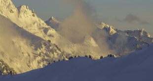

In winter, the North Cascades are truly in their element; simultaneously softened by the blanketing snow and rendered more dramatic by the relentless fury of the elements. It is a landscape of extraordinary beauty, carved and chiseled by the weather of eons gone by. This is their season.
Summer, as they say, is a beautiful lie.

The Mt. Baker Highway is your gateway to the spectacular peaks, slopes and valleys above the North Fork of the Nooksack River. Diverse joys await those who venture out on snowshoes—the unique and profound hush of snow-covered forests, the gleaming of row upon row of snow-covered summits, the singular joy of a day well spent in an exceptional place. And yes, even solitude, that sometimes elusive commodity, can often be found in the silent backcountry.
Options are plentiful and frequently glorious, ranging from casual afternoon strolls to multi-day expeditions. Although avalanche hazards restrict access to many areas of the North Cascades in the depths of winter, there are plenty of wondrous destinations to explore on your snowshoes.
Here are some suggestions for both the experienced snow traveler and those new to the delights of winter exploration, listed from east to west (and highest to lowest) along the highway.

Artist Point — Trailhead elevation: 4100′. Accessed from the upper Mt. Baker Ski Area, this 5-mile roundtrip excursion is justifiably famous—and crowded. The journey from the Ski Area to Artist Point on a fine winter day is as good as it gets if you enjoy big, bedazzling views (and who doesn’t?). The route departs from the uppermost parking lot at the upper lodge, skirts the downhill runs, climbs to spectacular Austin Pass and then ascends to the sinuous spine of Kulshan Ridge. Low avalanche risk generally, but avoid the last switchback below the Ridge’s highest spot, Huntoon Point (which has slid) by heading directly up the steep ridge. Once aloft, the views of Shuksan and Baker (and a hundred others) will knock your gaiters off.
White Salmon Road (#3075) – Trailhead elevation: 3,400’. The White Salmon Road offers a relatively high elevation jaunt, which means a better likelihood of good snow conditions when lower elevations are snow-deprived. The route is accessed from a small parking area at a tight switchback on the Mount Baker Highway, 18 miles east of Glacier, just past milepost 51. An easy outing—great for beginners—the trail meanders for approximately 2.5 miles with an elevation loss of 300 – 600 feet and no avalanche issues. After about a mile there are gorgeous views of Shuksan and the Upper Nooksack Valley. Unique amongst these routes, the White Salmon Road offers a descent on the way in, necessitating a commensurate climb on the way back.

Hannegan Road (#32) – Trailhead elevation: 2,000’. Located 13.1 miles east of Glacier and one-half mile before the Salmon Ridge Cross Country Ski Area, the Hannegan Road climbs safely for 3.5 miles, gaining 1,100 feet. The first mile is on an easy grade with some classic views of Mt. Shuksan and the usually free-flowing Nooksack River (scenic highlights of the trip), then the road steepens for the last two miles in the trees. Beyond this point, there is significant avalanche hazard and travel is not recommended. Up to the slide areas, however, the Hannegan road provides the easiest and most accessible snow trail in the Nooksack River Valley.
Twin Lakes Road (#3065) – Trailhead elevation: 2,000’. Located 12.7 miles east of Glacier at the Shuksan Maintenance Shed, the Twin Lakes Road is seven miles long with elevation gain (depending on how far you go) of as much as 3,000’. Parking is along the side of the road—not in the maintenance yard. A steep uphill climb to a magnificent area, the safe route ends three miles before Twin Lakes, at the Yellow Aster Butte trailhead (readily identified thanks to its stalwart outhouse). Beyond here, an extremely dangerous avalanche area is encountered. The road is closed to snowmobiles and the silence is sweet.

Wells Creek Road (#33) – Trailhead elevation: 1,800’. Located seven miles east of Glacier at the Nooksack Falls turnoff, the Wells Creek Road is 12 miles long, gaining up to 2800 feet. Parking is on the highway or near the falls (a short detour offers a view of the often icicle-draped waterfall). The road is closed to vehicles and snowmobiles at Nooksack Falls from November 1 – July 1, making this a great destination for low elevation solitude and wildlife watching. Snow can be questionable here due to the low elevation but a visit in mid-winter when the snowline is sufficiently low offers great scenery and opportunities for snow camping. Caution however: the road crosses a frequent avalanche area three miles in at an old burn area.
Glacier Creek Road (#39) – Trailhead elevation: 1,000’. Located 0.7 miles east of the Glacier Public Service Center just inside the Mt. Baker-Snoqualmie National Forest Boundary, the Glacier Creek Road is 8.5 miles long (measured from the Thompson Creek Bridge) and gains 3,000’. Park along the roadside at snowline. One avalanche path crosses the road and runs occasionally. Although this route is popular with snowmobilers, it provides access to a variety of beautiful locales including the Heliotrope Ridge Trail which is off-limits to machines. Visit in midweek (when the snowmobiles are less numerous) or at the beginning or end of the season (when you can drive further up the road).
Deadhorse Road (#37) – Trailhead elevation: 1,000’. Located at the beginning of the Glacier Creek Road (#39), the Deadhorse Road snakes upwards for 14 miles, gaining 3,000 feet. Parking is along the side of the road at snow line. The route starts out fairly level along the Nooksack River and then begins a long gradual uphill climb the rest of the way. The trailhead to Skyline Divide is at 13 miles and this trail is an excellent early season destination (when you can drive much of the way up the road) with open slopes and great views. The lower sections of Deadhorse can offer great snowshoeing along the river but adequate snow pack at this elevation has been hard to come by in recent years.