


My morning watch began the way it had all summer.
At 03:56 a.m., I stepped into the wheelhouse of the MV David B and wrote in the logbook: August 10, wind calm, depth 110 feet, barometer 1012. Comments: rain and fog. Then I walked back to the galley, turned off all the lights, save one dim lamp under a cabinet. Outside, rain hammered the aluminum overhead. White, jagged waterfalls cut through fog and darkness like silver lightning as they cascaded down the sheer 3,000-foot cliffs. Water was everywhere in our anchorage at Fords Terror. Through the gloom of pre-dawn, I could barely make out the white overfalls from the narrows beyond the sandbar. The tide was falling, heading for a -2.7 foot low later that morning.
Risk is inseparable from beauty in the wild places we seek out. It’s why we seek them.
As I worked, I occasionally looked out the window. A shape drifted by in the dark. Gulls? No—an alder branch. With so much rain, maybe a mudslide had torn the branch free.
Sometime after six, my husband, Jeffrey, the David B’s captain, joined me in the galley. A couple of our guests sipped coffee in the saloon, the wood-fired cookstove kept us warm, and the aroma of baking muffins filled the air with promise.
Jeffrey said, “Christine, come look. I’ve never seen this before.”
“What?”
“Water’s coming in over the sandbar.”
I turned. Muddy water poured over the sandbar with the force of a flood. Seafoam fanned into our anchorage, marking the spill of water before subsiding.
Strange Currents

We looked at each other, perplexed. In twenty years of anchoring here, we’d never seen this. Water surged, slowed, then surged again, covering rocks on the bar and then minutes later re-exposing them.
Another tour boat nearby was preparing to leave. We knew their timing should have been fine, but as soon as their anchor came up, they were swept sideways on a current that should not have been there. Entranced, we stood and watched until, much to our relief, they abandoned the attempt to leave and reset their anchor.
Jeffrey and I ran through explanations. Had Dawes Glacier––the glacier at the head of Endicott Arm–– experienced a monstrous calving event? We’d been to the glacier the previous day, and the glacier had not calved an unusual amount of ice. Was there an earthquake nearby? I checked—nothing local. I thought back to the alder branch I had seen earlier.
“Landslide?” I suggested, looking out towards the sandbar. Something was up.
“Text Jackie,” Jeffrey said.
At 06:34, I messaged Dr. Jackie Caplan-Auerbach, our friend at Western Washington University, who studies landslides and volcanoes. Good morning! J and I are anchored in Fords Terror. There’s a crazy surge causing the water to rise and fall 2–3 feet [later revised to approximately 10 feet] on a falling tide. Is there any seismic data that would indicate a landslide somewhere?
At 06:51, she replied: There’s definitely something that happened at 13:28 UTC (05:28 local). I can’t find much data, but a landslide seems reasonable. I’ll keep looking… Are you safe?
The surges appeared to be easing, and at anchor, our boat, the David B, wasn’t showing any signs of movement. Although shaken, I replied, “Yes.”
By mid-morning, the Coast Guard reported that there were kayakers at Harbor Island who had lost gear and one of their kayaks when an unexpected wave rushed through their forest campsite. The Coast Guard issued a caution for Endicott Arm, but the growing number of scientists starting to work on the mystery still hadn’t pinned down the exact location or the exact event.
A Mountain Came Down
At 10:30, we went ashore on the sandbar. The surges had weakened, but when Jeffrey stepped away for a minute, the water in our anchorage surged out, leaving our skiff high and dry. The repercussions from this unknown event were still evident.
While I was ashore, Jackie texted again with a map. The pin wasn’t in Endicott Arm at all. It was in Tracy Arm, right at South Sawyer Glacier—nearly 40 miles away. I read her text several times before sharing it with our guests. Volume ~100 million cubic meters [later revised to ~65 million]. Equivalent to a M5.3 quake. A really big event.
I stared at the map in disbelief. Just days earlier, Jeffrey had changed our usual itinerary. Without that shift, we would have been anchored deep inside Tracy Arm, only miles from the glacier where the massive slide had occurred. I shuddered imagining the wave. A wave that quite likely would have been the last thing I would ever see.
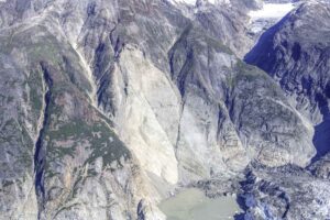
Later that day, Jackie sent me a video of the scar taken from a Coast Guard helicopter: an enormous gash nearly 4,000 feet high. The slide had indeed crashed onto South Sawyer Glacier, shattering and in places flattening its face and sending a tsunami to a height of nearly 1,500 feet up the opposite fjord wall.
I’ve had nightmares about such a wave: ice, mud, and water thundering up the fjord; reflected waves crashing back; the foaming teeth of a breaking wave roaring into the quiet inlet where we often anchor.
We began to hear reports of a couple of boats that had gone into Tracy Arm after the event. Unbelievably, Sawyer Island––a thickly forested island––had been stripped bare, and Williams Cove devastated. Our curiosity grew—would our usual anchorage have been survivable?
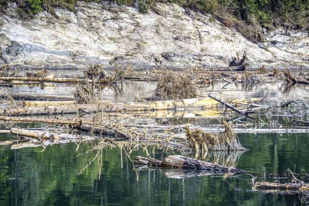
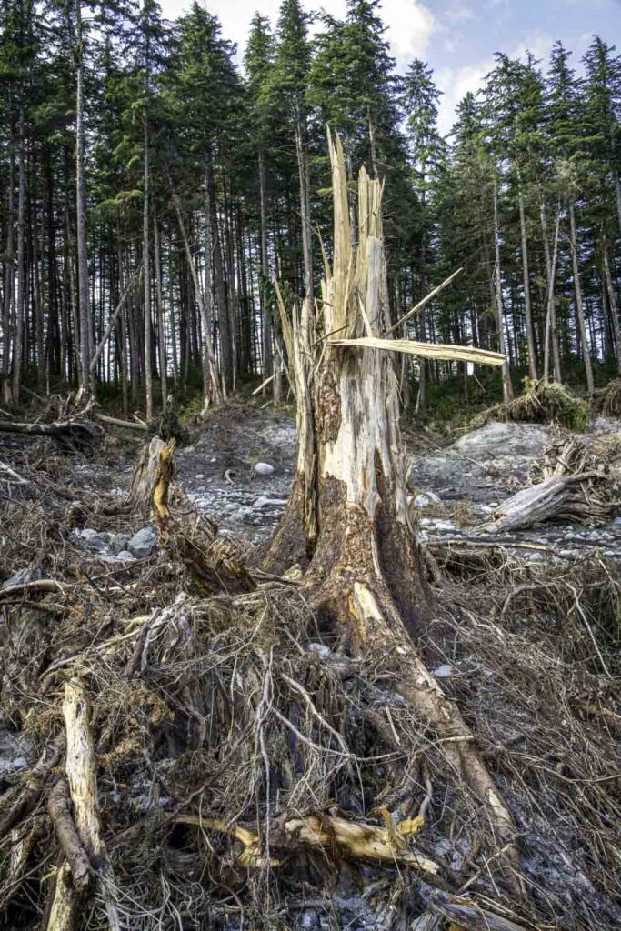
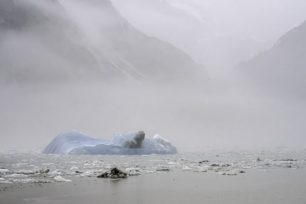
The next day, we crossed into Tracy Arm, motoring through fog and rain. The signs were immediate. Mature trees were adrift with their bark peeled and their branches frayed. At Williams Cove, the rockweed-covered beaches were scoured bare, trees toppled, gravel rearranged. Near the mudflats, there were signs that water had surged 150 feet up the fjord wall, stripping vegetation and stranding an iceberg on top of a rock. In a broad U-shaped valley, a lone tree stood where a grove had been a week earlier. Icebergs and tall trees floated together, the fjord thick with dirt-covered ice. Dense fog veiled the ice and debris, as if the fjord were asking for privacy. We pushed as far as we could before being forced to turn back.
The Big Picture

A couple of weeks later, still obsessed with the landslide and resulting tsunami, Jeffrey and I chartered a floatplane. From the air, we saw downed trees, cutlines, and a brown band of vegetation where saltwater had burned the leaves of alder and willow. The scale of damage caused by the displacement of water was almost too much to imagine.
South Sawyer Glacier bore a black eye, its face broken and sunken with rocks and dirt strewn across it. The scar itself was immense: an entire lobe of mountainside collapsed onto the glacier, breaking it up. Jeffrey noted how active that side of the glacier had been in the days before the slide and how different it looked now. Had the retreating glacier removed the mountain’s support?
We circled over Sawyer Island, once cloaked in spruce and shrubby vegetation, now stripped to rock. At North Sawyer Inlet, we traced the surge to our would-have-been anchorage. The bar was still there, but rocks that had fallen from above littered the beach. Willows where mountain goats spent their summers grazing were gone. I searched for signs of them, but the hillside was empty. Had they spooked in time to get to higher ground? I can only hope.
Looking at all that had happened from above, the only word that stood out in my mind was “unsurvivable.”
I’ve tried to imagine the mountainside falling and the force of the countless tons of rock hitting the glacier. I can clearly see the ice, water, and mud sloshing up the fjord wall and all the reflecting waves bouncing back and forth. It would have been deadly. Near the glacier, harbor seals spend their days hauled out on low ice floes. Could they have survived? I don’t know.
I do know what it feels like to be in the space where this all happened. I’ve seen large icebergs calve from South Sawyer. I’ve seen large waves rise and bounce off rock walls. I’ve watched icebergs crash into each other or break apart from surges caused by the birth of an iceberg. It can be terrifying or exhilarating, or both.
Fear, Wonder, Return
For two decades, Jeffrey and I have guided people to the tidewater glaciers of the Tracy Arm/Fords Terror Wilderness and Glacier Bay National Park. Hundreds of thousands of other people come here yearly on cruise ships, other charter boats, recreational boats, and kayaks—to experience face-to-face the towering wall of ice, to listen to these mighty rivers of ice crack and thunder, and to witness the eternal cycle of giant blocks of ice falling from glacier faces into icy-cold fjords. For many, it’s a pilgrimage of a lifetime. For me, it’s a lifelong connection to these wild places and a love of Nature herself.
Events like this are rare, but not unknown. Just north of Glacier Bay, Lituya Bay’s 1958 megatsunami created a 1,700-foot wave. More recent slides in Taan Fiord and Bute Inlet remind us that rock, ice, and water are volatile companions. As the climate warms and changes, the glaciers I know and love continue to retreat, and it seems that after millennia of filling their fjord-beds, their absence may be exposing weaknesses in mountainsides and steep slopes.
The Tracy Arm landslide of August 10, 2025, would go down as one of the most significant landslide-generated tsunamis in recorded history.
As summer waned on the Alaska Coast, we returned to Tracy Arm and the Sawyer Glaciers, although we refrained from anchoring at North Sawyer Inlet. It felt too soon, as the South Sawyer was still calving off large amounts of ice from the impact of the landslide, and there was still a threat of a secondary, yet smaller landslide. But somehow, it was important to return, to witness, and to tell South Sawyer’s story.
Risk is inseparable from beauty in the wild places we seek out. It’s why we seek them. Although I carry a new caution that comes from witnessing the changes brought by this event, my reverence deepens. Nature can uproot and extinguish in moments, but she also regenerates.
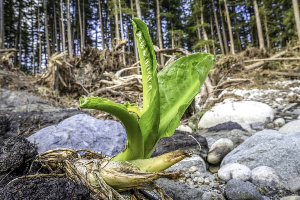
On the beach at Williams Cove, a month after the slide, I walked among toppled trees and scoured ground. Beneath the wreckage, skunk cabbage and horsetail pushed through torn soil. In the days after the landslide, I kept thinking about the nine lives of cats. I felt that the change Jeffrey made to our itinerary that kept us from anchoring in Tracy Arm before the landslide hit had stripped away one of my own nine lives. But walking among the new growth, I began to feel that I may have gained one, rooted in a greater love for this resilient wilderness.
A Wave Taller than the Empire State Building
By Dr. Jackie Caplan-Auerbach
At 5:26 a.m. Alaska Daylight Time, on August 10, some 65 million cubic meters of rock on the side of the Tracy Arm suddenly gave way. This enormous landslide collapsed into the fjord, knocking 50 acres of ice from the South Sawyer Glacier. The impact of ice and rock in the water generated a wave that sloshed up the opposite side of the canyon, wiping away trees, bushes, dirt, and lichen to a height of over 1500 feet. By comparison, the Empire State Building is only 1450 feet, if one includes the antenna at the top.
The displaced water then turned back to the Tracy Arm and roared down the valley; at its fastest, the tsunami moved at more than 130 mph. On either side of the fjord, it cleared vegetation from the walls—in some places, trees were torn away as high as 150 feet above the water. Nearly all vegetation on the 110-foot-tall Sawyer Island was washed away—only a single tree now remains on what was once a forested island. Over 24 hours after the slide, water continued to slosh in the Tracy and Endicott area. Miraculously, no boats were present in the Tracy Arm at the time of failure. At another time and on another day, the incident could have caused significant loss of life.
A review of seismic data recorded in the area shows that tiny earthquakes were recorded for more than 12 hours before the landslide. It is likely that these quakes, much too small to be felt by humans, represent the first bit of slip on the base of the slide. The number and size of the earthquakes increased over time, eventually merging into continuous stuttering. Such events are rare—precursory quakes like these have been identified in fewer than a dozen landslides globally—but rapid identification of sequences like this could one day provide a means by which a subset of landslides could be predicted.
Risk
By Jeffrey Smith
We all deal with risk in some way on our own. You can’t do anything outdoors that doesn’t have risk associated with it, and we all like to go to these spots where it’s unavoidable. It might be rockfall, or snow and ice, or motorists passing you inches away from your handlebars, but it’s always there. Even when we see others taken by those same risks, we keep going. Those places are beautiful, and those endeavors are enjoyable. A guest on my tour boat once described the raw beauty of Glacier Bay National Park as inviting, partly because it was “so inhospitable”. It’s risky. It’s not an easy place for us to be. But we keep going back because it’s stunningly beautiful, and that outweighs all the other risks.
We share our stories of these risks, too. Over a drink, or on the dock or the trail, we talk about our experiences. We connect over the stories that ultimately help form bonds between us. “You faced that?” “You escaped that?” “We did too.” It’s like we’re all on the same team, facing off against an opponent of risk and fear. When one of us wins, we celebrate them, and the cohesiveness of “team” tightens. Strangely, the same happens when one of us loses. It brings the rest of the team off the bench to rally with everyone, and the friendships of the survivors grow.
 Christine Smith wears many hats. As the owner/operator of Northwest Navigation/David B Cruises, she combines her love for adventure and nature by guiding others on unforgettable journeys in Alaska. Also an author and naturalist, she enjoys photography, hiking, and journaling. Learn more at NorthwestNavigation.com
 Jeffrey Smith, co-owner of the M/V David B, has spent a lifetime on the water—from tall ships to Alaska expeditions. Based in Bellingham with his wife Christine and their three cats, he loves sharing his deep knowledge of navigation, wildlife, and wooden-boat craftsmanship with guests.
 Jackie Caplan-Auerbach is a professor in the Geology Department at Western Washington University, where she teaches classes ranging from introductory geology to graduate courses in geophysics. A seismologist by training, her research focuses on hazards, notably the earthquakes that take place in association with volcanoes and landslides.
This is an incredible story. Thank you so much for sharing it. We were in Tracy Arm Fjord in 2017 on a cruise ship and witness some amazing calving. I cant Believe there were no boats around when this happened!!