


With crisp air, deep blue skies, no bugs and vibrant foliage—fall is my favorite time to hit the trail. I’ve hiked over 18,000 miles in Washington State from the wild Olympic Coast to the grizzly-harboring Selkirk Mountains. And while most of the peaks, forests, lakes, and river valleys I’ve trudged across make great autumn destinations; the ten below represent the cream of the crop when it comes to capturing the full essence of fall hiking in Washington State.
1. Ptarmigan Ridge
Mount Baker Wilderness Roundtrip: 11 miles Elevation Gain: 1735 feet

Traverse a rocky knolled spine above sprawling glaciers to almost within embracing distance of Mount Baker. Hike across snowfields that never retreat in summer’s heat and crimson carpets of ground-hugging blueberry bushes. Watch for goats and this ridge’s namesake diligently foraging before winter’s white shroud cloaks the ridge. Follow this exhilarating trail all the way to a grassy 6500-foot bluff above the Sholes Glacier and beneath the Portals – a knife edge separating three massive glaciers. Stare straight ahead at Baker and the crevassed glory of the Rainbow Glacier. Then face east and return, now marveling at Mount Shuksan before you.
2. Maple Pass
North Cascades Scenic Highway Roundtrip: 7.2 miles Elevation Gain: 2000 feet

On a per-mile-basis, the Maple Pass Loop is perhaps the most scenic hike along the breathtaking North Cascades Highway! In this seven mile loop you’ll be treated to majestic old-growth forests, a sparkling high-country lake, resplendent alpine meadows, and enticing wide open ridges granting stunning North Cascades vistas. In autumn, a smattering of larches adds touches of gold to the dramatic cirque cradling the aforementioned Lake Ann glistening 1,000 feet directly below. The only thing prettier? All of this with a fresh blanketing of snow.
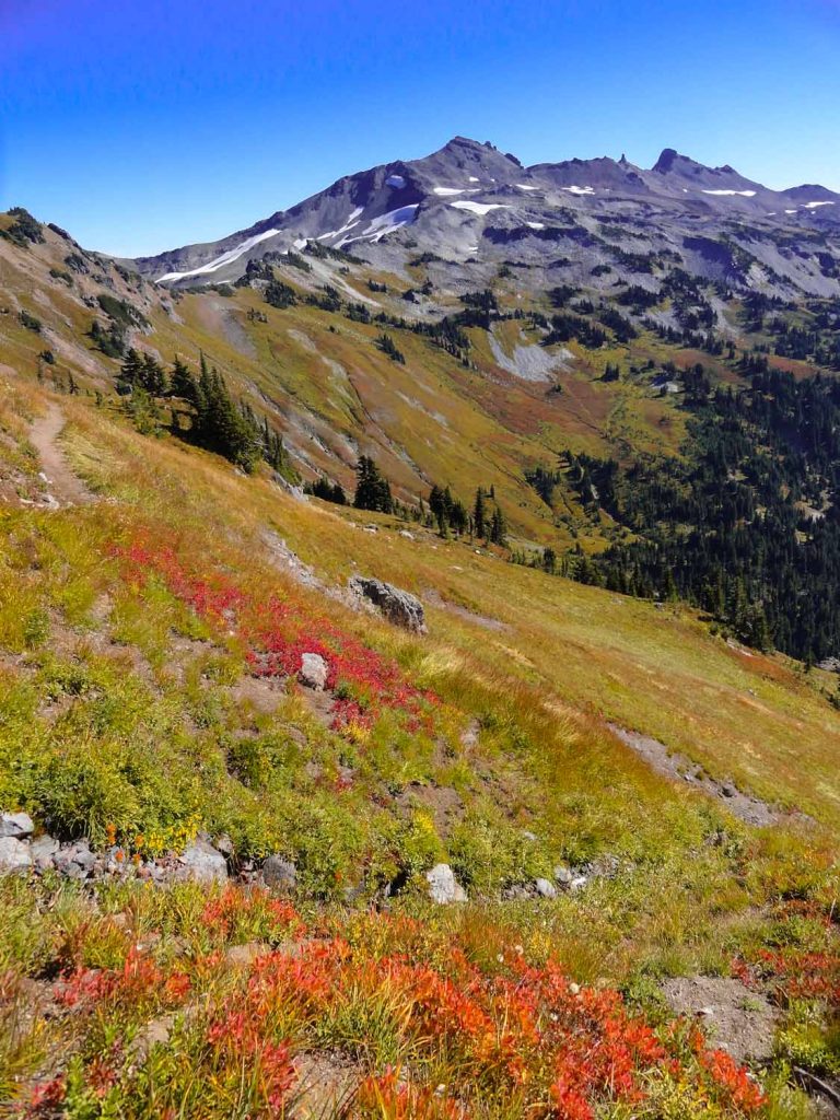
3. Twisp Pass
Lake Chelan-Sawtooth Wilderness Roundtrip: 9.0 miles Elevation Gain 2,450 feet

From the site of Gilbert, a long lost mining town, follow a route once used by hardscrabble prospectors up a wide glacier-carved valley to a 6,064-foot gap high in the mountains. Come October the scenery is spellbinding thanks to clusters of alpine larches coating the high slopes in golden hues and blueberry bushes blanketing the alpine meadows in vibrant scarlet. Paralleling the Twisp River, steadily ascend, alternating between lush cool forest and sunny open ledges. At Twisp Pass, saunter a ways north up an abandoned, (but easily followed) trail through groves of glowing larches and berry patches set afire in red.
4. Columbia Mountain
Kettle River Range Roundtrip: 8.0 miles Elevation gain: 1360 feet

At 5,575 feet, Sherman Pass is the highest pass in Washington crossed by a state highway. Amble along the lofty Kettle Crest to an historic lookout built in 1914. The adventure begins by following the Kettle Crest Trail north to the Columbia Mountain Loop Trail. Then gently climb through sun-kissed and sage-scented meadows circling the peak before reaching its 6,780-foot summit. Enjoy sweeping views of the lofty Kettle River Range – among the highest and wildest peaks in Eastern Washington – and marvel at entire ridges painted in hues of yellow thanks to thick stands of western larches and groves of aspens.
5. Grand Valley
Olympic National Park Roundtrip: 8.0 miles Elevation Gain: 2,100 feet
Hike to a necklace of sparkling alpine lakes in a mile-high valley set against bold mountain faces. Deer, marmots and bears are prolific in this valley. In autumn this wild kingdom is accented with golden sedges and fiery red berry bushes. Lounge or spend the night at one of three lakes. Grand Lake is grand indeed. Moose Lake boasts a spectacular backdrop of black-shale peaks. And little Gladys Lake is set in a high grassy and moraine-filled bowl. Your ticket into this majestic valley comes at a minimal cost. Start high, traverse open alpine tundra – then rapidly descend. Pay the piper on the grueling ascent back to your car.
6. Lake Ingalls
Alpine Lakes Wilderness Roundtrip: 9.2 miles Elevation Gain: 2600 feet
Cradled in a high barren basin beneath the rocky façade of Ingalls Peak, Lake Ingalls is a sight to behold. When its icy waters are calm, capturing reflections of the sheer rock face of 9415-foot Mount Stuart – one of the highest non-volcanic peaks in the state – the view is striking. When surrounding alpine larches set the lake basin and surrounding slopes aglow in gold, the scene is spellbinding. Mountain goats are ubiquitous here. And the views along the way of the old mining district of Esmeralda Basin to Mount Rainier in the southern horizon are sublime.
7. Shriner Peak
Mount Rainier National Park Roundtrip: 8.5 miles Elevation gain: 3,400 feet
The loneliest of Rainier’s four remaining fire lookouts, Shriner looks out over the quiet southeast country of the park. This 5,834-foot peak never gets crowded and consequently, chances are good for viewing wildlife. In the past, much of the peak was engulfed in wildfire creating open meadows and prime wildlife habitat. Bear, deer, grouse, cougar, and ground squirrels scamper about Shriner. And come fall, the old burn zone’s berry bushes and mountain ashes transform the verdant summit to red, yellow, and orange. The views are beautiful too – from Rainier and the craggy Cowlitz Chimneys to the virgin forests of the Ohanapecosh Valley below.
8. Hawkeye Point
Goat Rocks Wilderness Roundtrip loop: 14.7 miles Elevation Gain: 3100 feet
From this old lookout site at more than 7,400-feet, gaze straight down into a barren cirque cradling a large lake which remains frozen all but the early days of autumn. Then sight Mount Adams to the south, Mount Rainier to the north, Mount St. Helens to the west – and the serrated snow-capped Goat Rocks Crest filling the east. Legions of mountain goats roam the alpine tundra carpeting this corner of the Goat Rocks. Comprised of the Snowgrass Flat, Lily Basin, and Goat Ridge trails; this is one of the most scenic loops in the Cascades. It can be completed in a day by strong hikers or as a nice weekend backpacking adventure.
9. Strawberry Mountain
Gifford Pinchot National Forest Roundtrip: 8.8 miles Elevation Gain: 1700 feet
One of the finest ridge hikes within the shadows of Mount St. Helens, the only thing sweeter than Strawberry Mountain’s views are its succulent huckleberries. Roam across this sprawling peak through berry patches, silver forests, old-growth groves, sprawling meadows and pumiced slopes – all while marveling at sweeping views encompassing Mount St. Helens, Mount Rainier, the Goat Rocks and everything in between. A trail runs for 10 miles along this lofty elongated peak. But you can access it high up and midway from FR 2516. Walk north over and around a series of knolls to just below the steep 5720-foot summit. Views are great all along the way.
10. Diamond Peak
Wenaha-Tucannon Wilderness Roundtrip: 2.2 miles Elevation Gain: 500 feet
Follow the Mount Misery Trail – a rather pleasant path actually – on an easy hike along the rooftop of Washington’s lonely Blue Mountains to a stunning viewpoint. Immediately enter the 177,465-acre Wenaha-Tucannon Wilderness, spanning the Blues in both Washington and Oregon. Traverse wildlife-rich meadows and slopes graced in blueberries and larches which in fall add vibrant colors to this oft-muted landscape. Branch off on a short spur to 6,379-foot Diamond Peak, second-highest summit in Southeastern Washington and savor breathtaking views from Hells Canyon to the high Wallowa Mountains of northeastern Oregon.
 Craig Romano has written and co-written 14 books, mostly on hiking. He logs well over a 1,000 miles on the trail each year. His 100 Classic Hikes Washington (due spring 2016) spotlights the very best trails the state has to offer. He lives with his wife, son, and two cats in Skagit County. Visit him at CraigRomano.com.


I can’t find Hawkeye Point in any trail app. Could it go by another name? Looking for specific nav details. Thanks!
Hi Carolyn, Here’s a link: http://www.nwhiker.com/GPNFHike78.html