
Note: This eruption story is one of only several possible scenarios for an eruption of Mount Baker. This one is based on the 6600 year old ‘BA’ tephra eruption, the largest from Sherman Crater in the geologic record. A lahar is generated. Certainly a number of other Baker variations could be told. Much depends on wind direction, height and volume of the eruption plume, whether or not a volcanic landslide and lahar develop and in what drainage(s).
It started gradually.
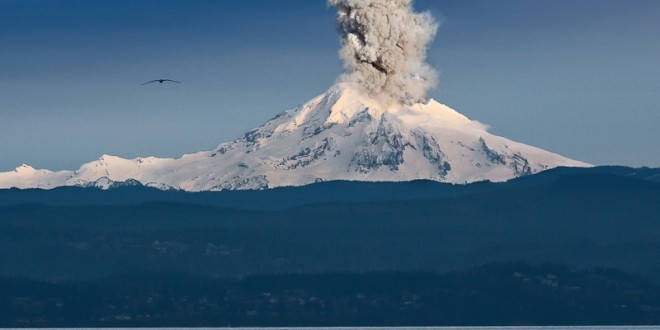
In late May, four little earthquakes were detected on two consecutive days beneath Mount Baker by the one working seismometer on the volcano’s flanks (the second, damaged by winter storms, had not been repaired due to budget cuts). Just little earthquakes, you’d never feel them. Two days later there were a dozen more, and the telemetered signals caused scientists at the Pacific Northwest Seismic Network and Cascade Volcano Observatory to sit up. By the end of the week swarms of tremors were detected; the largest was magnitude 1.2. Multiple instruments would be needed to help locate the depth of the tremors. The United States Geological Survey (USGS) convinced the Forest Service to short circuit the permitting process so a Western Washington University (WWU) geology professor could immediately install two of her instruments with student attendants at road heads. Her instruments couldn’t send data via modem link, but could be downloaded daily to laptops. On June 4, there were hundreds of earthquakes. The largest had a magnitude of 3.5, by far the largest earthquake ever recorded at Baker and depths were estimated at 3.5 miles. More seismometers from USGS and WWU were installed. Two weeks after the first earthquakes a large, discolored steam plume rose several thousand feet above Sherman Crater. The next day the plume was larger, very visible from the lowlands and mini-earthquakes occurred many times a day, two miles below the surface.
Similar precursory activity had occurred at other volcanoes that had erupted over the past few decades: Mount St. Helens in 1980 and 2004, Redoubt and Spurr in Alaska, and now it was happening at Mount Baker. Recent geologic studies of Baker’s past eruption deposits indicated ash could erupt. There was an outside chance of lava flows. A monstrous explosive blast like St. Helens 1980 wasn’t expected because the chemistry and behavior of the magma at the two volcanoes was different. The principal hazards preserved in Baker’s geologic record were gigantic landslides from the volcano’s upper slopes which transformed in river valley to form lahars. These thick flows of mud, boulders, trees and ice had swept repeatedly down the volcano into adjacent valleys, inundating Park, Boulder, Rocky, and Sulphur creeks. The largest lahar occurred around 6800 years ago. It swept down the Middle Fork of the Nooksack River and left over 30 feet of mud, boulders and logs at the modern site of Nugent’s Corner and built the terrace where Deming sits. These flows originated in rock weakened by acidic sulfurous gases rising from magma into the mountain. The chemical alteration turns solid rock into clay, lubricates layers between solidified lava flows, and makes great thicknesses of the volcano susceptible to gravity-induced sliding– and no eruption required!

Baker had briefly sputtered in 1975, when heat output increased substantially. A hole had melted through the 100-foot-thick ice in Sherman Crater, 1000 feet below the summit on the volcano’s south flank, revealing a muddy, bubbling lake. Dirty clouds of rotten-egg smelling steam rose much higher than usual. A dozen volcanologists kept watch and tested new instruments. No seismicity was detected, but then no seismometers were installed until after the main events had occurred. Magma was probably injected into the mountain’s depths and heated saturated rock in the volcano but never reached the surface. The blasting steam had only reamed old rock off the sides of the crater’s fumarole vents. Monitoring methods perfected at Baker proved useful five years later at St. Helens.
Now, 40 years later, seismicity increased almost daily. The combination of so many seismic signals and increased heat at the crater indicated that toothpaste-thick andesitic magma was making its way upward by fracturing rock below the volcano. The operators of the Upper Baker Dam on Baker Lake lowered the reservoir level to accommodate possible lahars, as they had done in 1975. The mountain was closed to climbers, to the dismay of fully-booked guiding companies. The Middle Fork Nooksack and Baker Lake roads were closed at road blocks and patrolled by the Whatcom and Skagit County Sheriff’s Departments. The Mount Baker Highway was closed at Glacier. Residents of this valley town feared the economic pinch as hikers and die hard back-country skiers no longer came up the valley. But they were replaced by hordes come to watch the volcano and buy souvenir t-shirts, even if you couldn’t see much from the north side.

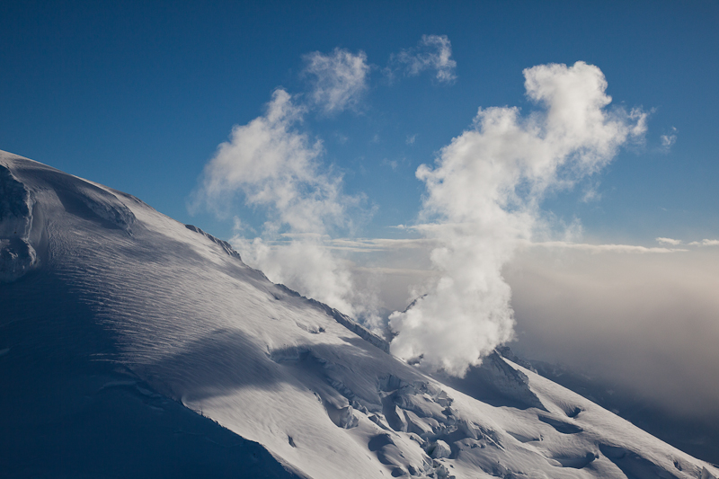
The upper slope of the mountain was now noticeably dark even from the lowlands, no longer mantled in pristine snow. Flown in by helicopter, nervous scientists sampled the dark material at the west crater rim, but found it was, like 1975, not fresh ash. Several GPS instruments sending data in real time were placed high on the mountain by USGS scientists and Mount Baker Volcano Research Center (MBVRC) volunteers to determine if the mountain was swelling outward from intruding magma. An aircraft with gas-detecting sensors flew around Sherman Crater when weather permitted, sniffing for changing chemical compositions, which might give more clues about the nature of the possible eruption.

Dirty plumes fumed upward daily. The ice in Sherman Crater began to fracture; fumaroles multiplied and grew larger. The lake reappeared through a hole melted in the ice. Twenty four days after the first little earthquakes and on the first evening of clear weather in a week, pilot John Scurlock photographed a gaping 450-foot-wide pit in the glacier just outside the west rim of Sherman Crater. The pit undercut the base of the Roman Wall and the 500-foot cliff of acid-altered lava flows on its eastern margin. Vigorous outbursts of dark steam roared out and fractured ice ringed the rim. Ten-foot high rock blocks on the mud-spattered glacier around the pit spoke of the force behind the steam blasts that reamed out of this new crater. On the next day, Scurlock watched from a distance as a series of steam blasts blew out the east rim of this new crater in a shower of mud and rocks as it merged with Sherman Crater.
At dawn on Day 26 a gigantic landslide carried away a 200-foot-thick slice of the Roman Wall and the overhanging lava cliffs, including the overlying icy mantle. The landslide, several hundred feet across, roared down the Deming Glacier, plugged the pit, entrained saturated snow, ripped up more glacier ice at ice falls and transformed into a concrete-like slurry of mud with huge slabs of rock. The 75-foot-deep lahar pitched off the terminus of the Deming Glacier to enter the Middle Fork Nooksack River. The lahar grew larger as it added more clay, sand and boulders from the river channel and the collapsing steep moraine walls lining the valley. Garage-sized boulders were carried in the steep-fronted slug of sodden sediment as it raced at 30 miles per hour beyond the Elbow Lake trail ford. Three yahoos from a national outdoor magazine snuck into the valley via gated roads in the Twin Sisters Range and were camped at the river’s edge. They were engulfed and never seen again.
Though the lahar thinned to only 10 feet, the low-slung bridge crossing the river towards the Twin Sisters and the olivine mine was smashed by surging logs. The lahar finally ran out of momentum 14 miles beyond its starting point, dropping the last of its load of boulders and cobbles. Dense muddy water continued downstream beyond the City of Bellingham’s water diversion tunnel to Lake Whatcom. The log-choked river overwhelmed the diversion dam, battered down the sluice gates and filled the tunnel with gritty mud, rendering it unusable. Thus ended the decades-long dispute with the Nooksack Tribe over the effect of the city’s water diversion on tribal fishing rights.
The muddy torrent joined the North Fork at Welcome and raised river levels all the way to the delta. The lahar’s rumbling was detected far up the valley by a series of telemetered acoustic monitors installed by the USGS to provide a warning that a lahar was on the way.
Four weeks into the renewed activity, gas-rich magma burst through the landslide debris in the new crater. For four hours, Baker’s new crater erupted repeatedly with dark roiling bursts of ash rising 3.5 miles into the atmosphere. Blocks of hot rock fell onto the volcano’s upper slopes, punching craters in the snow. The prevailing wind carried sandy ash to the north and east, showering four inches on Artist Point, an inch at Marblemount, and a half inch at Newhalem and Hope, B.C. – more than enough to damage gasoline engines, short out transformers and raise clouds of dust from passing cars. Highway 20 was gated at Sedro Woolley and Winthrop. The Trans-Canada Highway 1, Highway 3, the Coquihalla, and the railroad through the Fraser Gorge closed for three days from Chilliwack to Princeton and Merritt, stifling all transcontinental traffic. That night, the mountain erupted again. The ash column was lit by lightning from the static charges between rock fragments. No ash fell outside the north-east directed plume from the eruptions, and the Nooksack communities were spared altogether. A cloud of ash particles a fraction of an inch across were carried east in a thin, dispersed cloud over the next two days, closing air travel from Omaha to Chicago and Toronto, stranding hundreds of thousands. Ironically, SeaTac, Bellingham and Vancouver International closed as a precaution for only a few hours, though many departing flights were canceled because their flight paths would have traversed the plume.
Mount Baker’s first magmatic eruption in 6600 years was over. Gas and steam activity remained high in the new crater for another decade. The region dodged a bullet, as the only lahar was small and did not reach the Nooksack lowlands or enter the Skagit valley. Only the three journalists at Ridley Creek lost their lives. A couple of smart-aleck climbers who slipped in via the Glacier Creek Road were camped high on the Coleman Glacier and narrowly missed being killed by falling blocks in the first eruption; their camp was crushed. Summer rain made short work of the gritty ash accumulated on roads and houses from Hope to Marblemount. Lift equipment at the ski area was cleaned in time for the next ski season, though many a skier on Pan Dome glanced warily at Baker, steaming furiously in the distance, and the possibility of more eruptions kept many people away, while attracting others. The mountain was re-opened to climbers the next summer.

The longest-lasting effect resulted from the huge slug of sediment filling the upper Middle Fork Valley. After the lahar, the upper valley was coated in mud and carpeted with fallen trees in the thousands. For decades this great volume of sediment was flushed down the river to the Nooksack Delta. In the meantime, the river was choked with sediment, and overflowed its banks with much greater regularity than before the eruption. Lawsuits over land use and flood control mired farmers, tribal governments, the County and the State. Tribal fisheries were reduced for years by the suffocating effects of Mount Baker mud on salmon runs.
Two years later, new sandbars below Marine Drive diverted the Nooksack and destroyed Marietta, 63 river miles from Mount Baker, bringing about the community’s final evacuation. Hundreds of thousands of cubic yards of sand and mud entered Bellingham Bay, discoloring the water and extending the delta by several hundred yards on its east side. This nearly plugged the west entrance to Squalicum Harbor, which would require repeated dredging. For a few years, the road up the Middle Fork was crowded with tourists, come to see the lahar’s effects. Shops throughout northwest Washington and southern British Columbia sold bottles of ash and commemorative t-shirts. There was a bright side: Most of the new monitoring systems installed during the crisis remained in place and finally brought Mount Baker monitoring nearly to the recommended levels.

The Mount Baker Volcano Research Center

Mount Baker Volcano Research Center (MBVRC) is a Bellingham-based all-volunteer nonprofit dedicated to raising public awareness about Mount Baker eruption hazards. MBVRC raises funds to support scientific research on the volcano by selling Mont Baker t-shirts and offering geology-oriented field trips to the public. The MBVRC website includes an eruptive history of the volcano based on the latest geologic studies, videos inside active Sherman Crater, and links to animated eruption simulations based on each day’s wind patterns. E-mail subscribers receive first dibs on the ever-popular guided geology field trips. Speakers can be arranged for presentations about Baker eruption history and hazards. To learn more, visit www.mbvrc.wordpress.com. Donate to MBVRC via the blog, or contact MBVRC directly at research@mbvrc.wwu.edu.
 Dave Tucker is a director of the Mount Baker Volcano Research Center and also a research associate in the geology department at Western Washington University. Dave studies Baker geology, in particular the distribution of volcanic ash. He gives many public presentations about the geology of northwest Washington. His book, Geology Underfoot in Western Washington, a “people’s field guide”, will be published in Fall 2014. He lives in Bellingham.


My 6th grade and eventually, high school science teacher, Mrs. Mowrer, told the class that when mount baker goes, the dams will break and the entire Skagit valley will have 45 minutes to get out of the valley before everyone is washed out to sea… I realize that you said there are all sorts of scenarios that could happen, though in your scenario, (unless I missed it some how which I’m known to do lol because,hey no ones perfect) I didn’t see anything about the dams breaking… baker lake has a lot of water in it and so does lake shannon and the other bodies of water that are associated with baker and shannon… the Skagit River seems to flood every time a baby cries (lol), yet I didn’t see anything about it other than saying the Skagit valley dodged a bullet. Lol. I guess I just filled in the blanks for ya 🤷♀️. But like you said, there are many scenarios😉 and this was a pretty accurate description of the sweet meat especially that bit about the yahoos lol. 🖖