
When we think of the “North Cascades,” I’m sure we all have a certain image that pops into our heads. Perhaps it’s the awesome view of Mount Baker or Shuksan from Artist Point or one of the stunning vistas from the North Cascades Highway, like the Diablo Lake Overlook or Washington Pass. For me, it’s Glacier Peak and the Mountain Loop Highway between Granite Falls and Darrington.
In fact, I blame my hopeless addiction to mountains on the Mountain Loop. When I took up mountaineering, I approached many of the first peaks I climbed from said highway: White Chuck, Del Campo, Vesper, Sloan, Pugh, and Glacier Peak (for me, the symbolic center of the range), as well as Whitehorse and Pilchuck, summits that anchor the endpoints of this remarkable corridor.
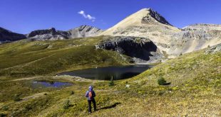
I often return to the Loop to bask in this vertical world’s rugged beauty. And now, as we drift into autumn and I’ve more or less satisfied my peak-bagging urge, my interest shifts to favored trails like Squire Creek Pass and Cutthroat Lakes. Who can resist the higher ground with its alpine reds and yellows tinged with frost, draped below ridges and spires dusted with October snow?
As the season advances, as the snowline falls, and my fingers freeze, I look more to mid-elevation hikes, like Perry Creek, historic Monte Cristo, the myriad lakes east of Granite Falls, and Barlow Point, where I can pretend I’m still at 5,000 feet because the view is so good. However, access can get a little tricky by November, when the highway typically closes, depending on conditions. It’s gated for the winter at Deer Creek and Bedal Campground, usually until May.

Officially completed in the early 1940s, history traces the Mountain Loop Highway’s roots to the discovery of gold and silver at Monte Cristo in 1889. Miners extended a wilderness wagon road up the Sauk River valley from Darrington to haul the ore to the smelter in Everett. But engineers soon realized a railway from Granite Falls over Barlow Pass would be far more efficient. The first train arrived in the bustling mountain town in 1893. However, the boom was over within a few years, and floods decimated the railroad tracks.
In the 1920s, railroad logging expanded rapidly up the Sauk, and vacationers and adventurers began to discover these new avenues into the mountains. In the 1930s, the Civilian Conservation Corps built roads, trails, and campgrounds along the future Mountain Loop, and the highway was officially dedicated in 1942.
Along its 54-mile length are numerous trailheads, campgrounds, picnic areas, river access points, and historic sites. Most of the two-lane highway is paved and well maintained, except for a 15-mile midsection of gravel, which can get a little rough in places, depending on when it was last graded.
Hikes
In early fall, consider a stiff hike up Mount Pilchuck on an excellent trail to the historic fire lookout (6.2 miles RT, 2,200-feet elevation gain, access near milepost 12.1) or a longer scenic trudge up Mount Dickerman, including fall color and a good look at Glacier Peak (8.4 miles RT, 3,900-feet elevation gain, access near milepost 27.4). These are popular hikes, and for good reason. For more elbow room, go on a weekday if possible.
Squire Creek Pass via the Eightmile Trail is steep and rugged but a fine choice for extensive views before the snowy months set in (5.6 miles RT, 2,300-feet elevation gain, access from the Clear Creek Road near milepost 50.8).

For a more moderate and family-friendly hike—sometimes on boardwalk planking—to Ashland Lakes (5.4 miles RT, 800-feet elevation gain). Walk as little or as much as you like while visiting these peaceful lakes surrounded by old-growth forests. The road to the trailhead is well-signed from the Loop at milepost 15.8.
Barlow Point rarely sees a crowd. Despite some steepish switchbacks, it’s just over a mile long with a 900-foot gain to the big view from an old fire lookout site. Find the trailhead at Barlow Pass (milepost 30.6).
Finally, you don’t want to miss the majestic view from the Big Four Picnic Area and Ice Caves trailhead at milepost 25.5. A barrier-free loop follows part of the historic Monte Cristo Railway grade, then crosses wetlands on a boardwalk to a river bridge. From there, the kid-friendly hike climbs another mile, gaining just 200 feet to full-on bliss.
 The author and publisher of Hiking Snohomish County (2024) and Hiking Whatcom County (2023), Ken Wilcox is a long-time Bellingham resident, writer, and professional trail planning/design consultant. He writes about parks, trails, Northwest history, and travel, and frequently posts his work via Substack at www.kenwilcox.com